Vigrestad geodata
Vigrestad (Rogaland) is a populated place; located in Norway in Europe/Oslo (GMT+2) time zone. With population of 1,764 people, there are 224 cities with bigger population in this country. Compared to other cities in Norway, 94.5% of cities are located further ↑North; 87.7% of cities are located further →East and 58.2% of cities have higher elevation than Vigrestad. Note1


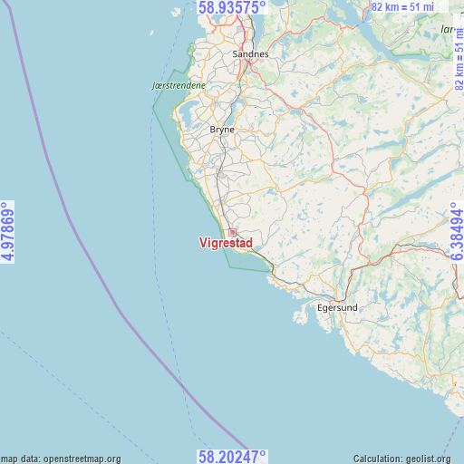
Vigrestad GPS coordinates[2]
58° 34' 15.708" North, 5° 40' 54.552" East
| Map corner | latitude | longitude |
|---|---|---|
| Upper-left | 58.93575°, | 4.97869° |
| Center: | 58.57103°, | 5.68182° |
| Lower-right: | 58.20247°, | 6.38494° |
| Map W x H: | 81.5×81.5 km | = 50.6×50.6mi |
| max Lat: | 71.04137° ⇑94.5% North |
| Vigrestad: | 58.57103° |
| min Lat: | ⇓5.5% South 58.0274° |
| min Long | Vigrestad | max Long |
| 4.71485° | 5.68182° | 31.11066° |
| W 12.3%⇐ | ⇒87.7% E |
Elevation
Elevation of Vigrestad is 30 m = 98 ft, and this is 74.2 m = 243 ft below average elevation for this country.
| Max E: |
897 m = 2943 ft | 58.2% |
| Avg. | 104.2 m = 342 ft | |
| Vigrestad | 30 m = 98 ft | |
Min E: |
1 m = 3 ft | 41.8% |
See also: Norway elevation on elevation.city.
Geographical zone
Vigrestad is located in North temperate zone (between Tropic of Cancer and the Arctic Circle). Distance of this North polar circle is 888.7 km =552.2 mi to North.| Distance of | km | miles | from Vigrestad |
|---|---|---|---|
| North Pole | 3494.6 | 2171.4 | to North |
| Arctic Circle | 888.7 | 552.2 | to North |
| Tropic Cancer | 3906.6 | 2427.4 | to South |
| Equator | 6512.5 | 4046.7 | to South |


Nearby cities:
15 places around Vigrestad: (largest is in red/bold)
• Bryne
18.4 km =11.4 mi,  353°
353°
• Egersund
22.8 km =14.2 mi,  125°
125°
• Hauge i Dalane
43.1 km =26.8 mi, 125°
• Hellvik
15.4 km =9.6 mi, 132°
• Hommersåk
40.6 km =25.2 mi,  13°
13°
• Kleppe
22.8 km =14.2 mi, 352°
• Lyefjell
18.5 km =11.5 mi, 9°
• Nærbø
10.8 km =6.7 mi, 346°
• Oltedal
35.2 km =21.9 mi,  35°
35°
• Sandnes
31.4 km =19.5 mi, 5°
• Sola
35.3 km =21.9 mi,  357°
357°
• Tananger
41.1 km =25.5 mi, 351°
• Varhaug
5.4 km =3.4 mi,  344°
344°
• Vikeså
24.8 km =15.4 mi,  72°
72°
• Ålgård
23.6 km =14.7 mi,  24°
24°
Sources, notices
• [Note1] Compared only with cities in Norway existing in our database
• [Src1] Map data: © OpenStreetMap contributors (CC-BY-SA)
• [Src2] Other city data from geonames.org with taken over terms of usage.
• [Src3] Geographical zone / Annual Mean Temperature by Robert A. Rohde @ Wikipedia
