Jaren geodata
Jaren (Oppland) is a seat of a second-order administrative division; located in Norway in Europe/Oslo (GMT+2) time zone. In our database, there are 488 cities with bigger population. Compared to other cities in Norway, 54.7% of cities are located further ↑North; 59.7% of cities are located further ←West and 90.3% of cities have lower elevation than Jaren. Note1


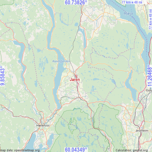
Jaren GPS coordinates[2]
60° 23' 33.828" North, 10° 33' 41.58" East
| Map corner | latitude | longitude |
|---|---|---|
| Upper-left | 60.73826°, | 9.85843° |
| Center: | 60.39273°, | 10.56155° |
| Lower-right: | 60.04349°, | 11.26468° |
| Map W x H: | 77.3×77.2 km | = 48×48mi |
| max Lat: | 71.04137° ⇑54.7% North |
| Jaren: | 60.39273° |
| min Lat: | ⇓45.3% South 58.0274° |
| min Long | Jaren | max Long |
| 4.71485° | 10.56155° | 31.11066° |
| W 59.7%⇐ | ⇒40.3% E |
Elevation
Elevation of Jaren is 290 m = 951 ft, and this is 185.8 m = 610 ft above average elevation for this country.
| Max E: |
897 m = 2943 ft | 9.7% |
| Jaren | 290 m 951 ft | |
| Avg. | 104.2 m = 342 ft | |
Min E: |
1 m = 3 ft | 90.3% |
See also: Norway elevation on elevation.city.
Geographical zone
Jaren is located in North temperate zone (between Tropic of Cancer and the Arctic Circle). Distance of this North polar circle is 686.1 km =426.3 mi to North.| Distance of | km | miles | from Jaren |
|---|---|---|---|
| North Pole | 3292 | 2045.6 | to North |
| Arctic Circle | 686.1 | 426.3 | to North |
| Tropic Cancer | 4109.1 | 2553.3 | to South |
| Equator | 6715 | 4172.5 | to South |


Nearby cities:
15 places around Jaren: (largest is in red/bold)
• Eina
26.3 km =16.3 mi,  4°
4°
• Grua
16.1 km =10 mi,  159°
159°
• Hallingby
24.7 km =15.3 mi,  236°
236°
• Hov
35.9 km =22.3 mi,  341°
341°
• Hurdal
28.2 km =17.5 mi,  80°
80°
• Hønefoss
30.1 km =18.7 mi,  213°
213°
• Jevnaker
19.5 km =12.1 mi, 209°
• Kolbu
30.3 km =18.8 mi,  19°
19°
• Lena
34.2 km =21.3 mi, 23°
• Maura
29.9 km =18.6 mi,  119°
119°
• Reinsvoll
32.1 km =19.9 mi,  5°
5°
• Roa
11.7 km =7.3 mi,  165°
165°
• Råholt
36.4 km =22.6 mi,  111°
111°
• Skreia
35.4 km =22 mi,  35°
35°
• Teigebyen
31.6 km =19.6 mi,  127°
127°
Sources, notices
• [Note1] Compared only with cities in Norway existing in our database
• [Src1] Map data: © OpenStreetMap contributors (CC-BY-SA)
• [Src2] Other city data from geonames.org with taken over terms of usage.
• [Src3] Geographical zone / Annual Mean Temperature by Robert A. Rohde @ Wikipedia
