Dokka geodata
Dokka (Oppland) is a seat of a second-order administrative division; located in Norway in Europe/Oslo (GMT+2) time zone. With population of 2,796 people, there are 136 cities with bigger population in this country. Compared to other cities in Norway, 53.8% of cities are located further ↓South; 50.3% of cities are located further →East and 81.2% of cities have lower elevation than Dokka. Note1


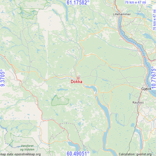
Dokka GPS coordinates[2]
60° 50' 6" North, 10° 4' 25.032" East
| Map corner | latitude | longitude |
|---|---|---|
| Upper-left | 61.17582°, | 9.3705° |
| Center: | 60.835°, | 10.07362° |
| Lower-right: | 60.49051°, | 10.77675° |
| Map W x H: | 76.2×76.2 km | = 47.3×47.3mi |
| max Lat: | 71.04137° ⇑46.2% North |
| Dokka: | 60.835° |
| min Lat: | ⇓53.8% South 58.0274° |
| min Long | Dokka | max Long |
| 4.71485° | 10.07362° | 31.11066° |
| W 49.7%⇐ | ⇒50.3% E |
Elevation
Elevation of Dokka is 180 m = 591 ft, and this is 75.8 m = 249 ft above average elevation for this country.
| Max E: |
897 m = 2943 ft | 18.8% |
| Dokka | 180 m 591 ft | |
| Avg. | 104.2 m = 342 ft | |
Min E: |
1 m = 3 ft | 81.2% |
See also: Norway elevation on elevation.city.
Geographical zone
Dokka is located in North temperate zone (between Tropic of Cancer and the Arctic Circle). Distance of this North polar circle is 637 km =395.8 mi to North.| Distance of | km | miles | from Dokka |
|---|---|---|---|
| North Pole | 3242.8 | 2015 | to North |
| Arctic Circle | 637 | 395.8 | to North |
| Tropic Cancer | 4158.3 | 2583.8 | to South |
| Equator | 6764.2 | 4203.1 | to South |


Nearby cities:
15 places around Dokka: (largest is in red/bold)
• Aurdal
37 km =23 mi,  285°
285°
• Bagn
28.3 km =17.6 mi,  267°
267°
• Bruflat
24.1 km =15 mi,  284°
284°
• Eina
36.6 km =22.7 mi,  128°
128°
• Follebu
43.8 km =27.2 mi,  15°
15°
• Forset
41 km =25.5 mi,  5°
5°
• Gjøvik
33.8 km =21 mi,  97°
97°
• Hov
21.4 km =13.3 mi,  135°
135°
• Kolbu
41.9 km =26 mi,  119°
119°
• Lena
44 km =27.3 mi,  114°
114°
• Lillehammer
37.7 km =23.4 mi,  34°
34°
• Moelv
35.6 km =22.1 mi,  72°
72°
• Raufoss
31.7 km =19.7 mi, 112°
• Reinsvoll
34.4 km =21.4 mi, 120°
• Segalstad bru
44.4 km =27.6 mi, 10°
Sources, notices
• [Note1] Compared only with cities in Norway existing in our database
• [Src1] Map data: © OpenStreetMap contributors (CC-BY-SA)
• [Src2] Other city data from geonames.org with taken over terms of usage.
• [Src3] Geographical zone / Annual Mean Temperature by Robert A. Rohde @ Wikipedia
