Oppeid geodata
Oppeid (Nordland) is a seat of a second-order administrative division; located in Norway in Europe/Oslo (GMT+2) time zone. In our database, there are 488 cities with bigger population. Compared to other cities in Norway, 88.8% of cities are located further ↓South; 91% of cities are located further ←West and 62.5% of cities have lower elevation than Oppeid. Note1


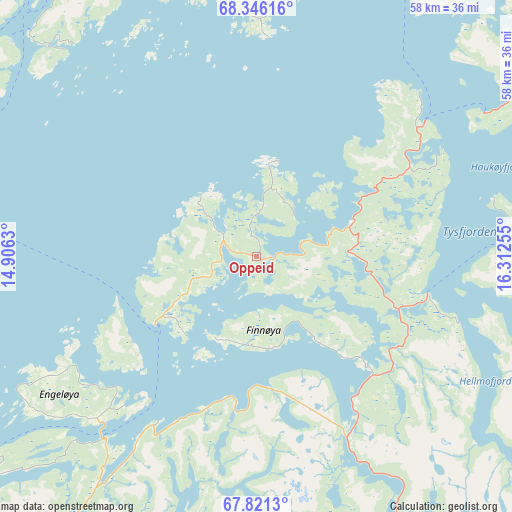
Oppeid GPS coordinates[2]
68° 5' 6.792" North, 15° 36' 33.912" East
| Map corner | latitude | longitude |
|---|---|---|
| Upper-left | 68.34616°, | 14.9063° |
| Center: | 68.08522°, | 15.60942° |
| Lower-right: | 67.8213°, | 16.31255° |
| Map W x H: | 58.4×58.4 km | = 36.3×36.3mi |
| max Lat: | 71.04137° ⇑11.2% North |
| Oppeid: | 68.08522° |
| min Lat: | ⇓88.8% South 58.0274° |
| min Long | Oppeid | max Long |
| 4.71485° | 15.60942° | 31.11066° |
| W 91%⇐ | ⇒9% E |
Elevation
Elevation of Oppeid is 80 m = 262 ft, and this is 24.2 m = 79 ft below average elevation for this country.
| Max E: |
897 m = 2943 ft | 37.5% |
| Avg. | 104.2 m = 342 ft | |
| Oppeid | 80 m = 262 ft | |
Min E: |
1 m = 3 ft | 62.5% |
See also: Norway elevation on elevation.city.
Geographical zone
Oppeid is located in North Frigid zone (between North Pole and Arctic Circle). Distance of this North polar circle is 169.2 km =105.1 mi to South.| Distance of | km | miles | from Oppeid |
|---|---|---|---|
| North Pole | 2436.7 | 1514.1 | to North |
| Arctic Circle | 169.2 | 105.1 | to South |
| Tropic Cancer | 4964.4 | 3084.7 | to South |
| Equator | 7570.4 | 4704 | to South |


Nearby cities:
15 places around Oppeid: (largest is in red/bold)
• Ballangen
58 km =36 mi,  60°
60°
• Bogen
75.1 km =46.7 mi,  49°
49°
• Evenskjer
68 km =42.3 mi,  35°
35°
• Hol
60.8 km =37.8 mi,  31°
31°
• Kabelvåg
49 km =30.4 mi,  286°
286°
• Kjøpsvik
31.8 km =19.8 mi,  87°
87°
• Leinesfjorden
42.4 km =26.3 mi,  215°
215°
• Lødingen
39.9 km =24.8 mi,  23°
23°
• Melbu
57.1 km =35.5 mi,  324°
324°
• Sigerfjord
62.2 km =38.6 mi,  356°
356°
• Sortland
68.4 km =42.5 mi,  352°
352°
• Stamsund
73.1 km =45.4 mi,  273°
273°
• Stokmarknes
60.5 km =37.6 mi,  331°
331°
• Strand
68.4 km =42.5 mi, 354°
• Svolvær
46.1 km =28.6 mi, 291°
Sources, notices
• [Note1] Compared only with cities in Norway existing in our database
• [Src1] Map data: © OpenStreetMap contributors (CC-BY-SA)
• [Src2] Other city data from geonames.org with taken over terms of usage.
• [Src3] Geographical zone / Annual Mean Temperature by Robert A. Rohde @ Wikipedia
