Sortland geodata
Sortland (Nordland) is a seat of a second-order administrative division; located in Norway in Europe/Oslo (GMT+2) time zone. With population of 4,620 people, there are 98 cities with bigger population in this country. Compared to other cities in Norway, 92.4% of cities are located further ↓South; 90.3% of cities are located further ←West and 88.6% of cities have higher elevation than Sortland. Note1


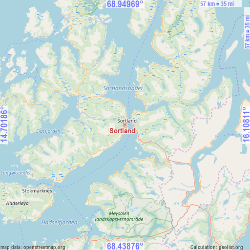
Sortland GPS coordinates[2]
68° 41' 44.484" North, 15° 24' 17.928" East
| Map corner | latitude | longitude |
|---|---|---|
| Upper-left | 68.94969°, | 14.70186° |
| Center: | 68.69569°, | 15.40498° |
| Lower-right: | 68.43876°, | 16.10811° |
| Map W x H: | 56.8×56.8 km | = 35.3×35.3mi |
| max Lat: | 71.04137° ⇑7.6% North |
| Sortland: | 68.69569° |
| min Lat: | ⇓92.4% South 58.0274° |
| min Long | Sortland | max Long |
| 4.71485° | 15.40498° | 31.11066° |
| W 90.3%⇐ | ⇒9.7% E |
Elevation
Elevation of Sortland is 5 m = 16 ft, and this is 99.2 m = 325 ft below average elevation for this country.
| Max E: |
897 m = 2943 ft | 88.6% |
| Avg. | 104.2 m = 342 ft | |
| Sortland | 5 m = 16 ft | |
Min E: |
1 m = 3 ft | 11.4% |
See also: Norway elevation on elevation.city.
Geographical zone
Sortland is located in North Frigid zone (between North Pole and Arctic Circle). Distance of this North polar circle is 237.1 km =147.3 mi to South.| Distance of | km | miles | from Sortland |
|---|---|---|---|
| North Pole | 2368.8 | 1471.9 | to North |
| Arctic Circle | 237.1 | 147.3 | to South |
| Tropic Cancer | 5032.3 | 3126.9 | to South |
| Equator | 7638.2 | 4746.2 | to South |


Nearby cities:
15 places around Sortland: (largest is in red/bold)
• Bogen
67.1 km =41.7 mi,  106°
106°
• Borkenes
32.1 km =19.9 mi,  74°
74°
• Evenskjer
48.9 km =30.4 mi,  104°
104°
• Harstad
47.2 km =29.3 mi,  76°
76°
• Hol
43.2 km =26.8 mi, 112°
• Kabelvåg
65.9 km =40.9 mi,  215°
215°
• Lødingen
39.5 km =24.5 mi,  142°
142°
• Melbu
32.6 km =20.3 mi,  228°
228°
• Myre
27.6 km =17.1 mi,  331°
331°
• Myre
50.8 km =31.6 mi,  26°
26°
• Sigerfjord
7.2 km =4.5 mi, 143°
• Stokmarknes
24.8 km =15.4 mi, 233°
• Strand
1.8 km =1.1 mi, 84°
• Straume
37.7 km =23.4 mi,  268°
268°
• Svolvær
61.6 km =38.3 mi,  213°
213°
Sources, notices
• [Note1] Compared only with cities in Norway existing in our database
• [Src1] Map data: © OpenStreetMap contributors (CC-BY-SA)
• [Src2] Other city data from geonames.org with taken over terms of usage.
• [Src3] Geographical zone / Annual Mean Temperature by Robert A. Rohde @ Wikipedia
