Melbu geodata
Melbu (Nordland) is a populated place; located in Norway in Europe/Oslo (GMT+2) time zone. With population of 2,161 people, there are 184 cities with bigger population in this country. Compared to other cities in Norway, 91% of cities are located further ↓South; 89.4% of cities are located further ←West and 81.6% of cities have higher elevation than Melbu. Note1


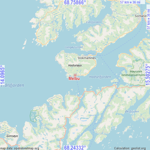
Melbu GPS coordinates[2]
68° 30' 8.856" North, 14° 47' 58.632" East
| Map corner | latitude | longitude |
|---|---|---|
| Upper-left | 68.75866°, | 14.0965° |
| Center: | 68.50246°, | 14.79962° |
| Lower-right: | 68.24332°, | 15.50275° |
| Map W x H: | 57.3×57.3 km | = 35.6×35.6mi |
| max Lat: | 71.04137° ⇑9% North |
| Melbu: | 68.50246° |
| min Lat: | ⇓91% South 58.0274° |
| min Long | Melbu | max Long |
| 4.71485° | 14.79962° | 31.11066° |
| W 89.4%⇐ | ⇒10.6% E |
Elevation
Elevation of Melbu is 10 m = 33 ft, and this is 94.2 m = 309 ft below average elevation for this country.
| Max E: |
897 m = 2943 ft | 81.6% |
| Avg. | 104.2 m = 342 ft | |
| Melbu | 10 m = 33 ft | |
Min E: |
1 m = 3 ft | 18.4% |
See also: Norway elevation on elevation.city.
Geographical zone
Melbu is located in North Frigid zone (between North Pole and Arctic Circle). Distance of this North polar circle is 215.6 km =134 mi to South.| Distance of | km | miles | from Melbu |
|---|---|---|---|
| North Pole | 2390.3 | 1485.3 | to North |
| Arctic Circle | 215.6 | 134 | to South |
| Tropic Cancer | 5010.8 | 3113.6 | to South |
| Equator | 7616.8 | 4732.9 | to South |


Nearby cities:
15 places around Melbu: (largest is in red/bold)
• Borkenes
63.1 km =39.2 mi,  61°
61°
• Evjen
50.9 km =31.6 mi,  239°
239°
• Hol
65 km =40.4 mi,  85°
85°
• Kabelvåg
35.1 km =21.8 mi,  202°
202°
• Leknes
62.8 km =39 mi,  231°
231°
• Lødingen
49.8 km =30.9 mi,  101°
101°
• Myre
47.1 km =29.3 mi,  13°
13°
• Oppeid
57.1 km =35.5 mi,  144°
144°
• Sigerfjord
32.9 km =20.4 mi, 61°
• Sortland
32.6 km =20.3 mi,  48°
48°
• Stamsund
56.9 km =35.4 mi,  223°
223°
• Stokmarknes
8.3 km =5.2 mi,  33°
33°
• Strand
34.1 km =21.2 mi, 50°
• Straume
24.6 km =15.3 mi,  327°
327°
• Svolvær
31.3 km =19.4 mi, 197°
Sources, notices
• [Note1] Compared only with cities in Norway existing in our database
• [Src1] Map data: © OpenStreetMap contributors (CC-BY-SA)
• [Src2] Other city data from geonames.org with taken over terms of usage.
• [Src3] Geographical zone / Annual Mean Temperature by Robert A. Rohde @ Wikipedia
