Leinesfjorden geodata
Leinesfjorden (Nordland) is a seat of a second-order administrative division; located in Norway in Europe/Oslo (GMT+2) time zone. In our database, there are 488 cities with bigger population. Compared to other cities in Norway, 88.3% of cities are located further ↓South; 89.7% of cities are located further ←West and 54.7% of cities have higher elevation than Leinesfjorden. Note1


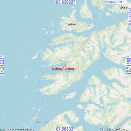
Leinesfjorden GPS coordinates[2]
67° 46' 31.728" North, 15° 0' 55.62" East
| Map corner | latitude | longitude |
|---|---|---|
| Upper-left | 68.03992°, | 14.31233° |
| Center: | 67.77548°, | 15.01545° |
| Lower-right: | 67.50802°, | 15.71858° |
| Map W x H: | 59.1×59.1 km | = 36.7×36.7mi |
| max Lat: | 71.04137° ⇑11.7% North |
| Leinesfjorden: | 67.77548° |
| min Lat: | ⇓88.3% South 58.0274° |
| min Long | Leinesfjorden | max Long |
| 4.71485° | 15.01545° | 31.11066° |
| W 89.7%⇐ | ⇒10.3% E |
Elevation
Elevation of Leinesfjorden is 35 m = 115 ft, and this is 69.2 m = 227 ft below average elevation for this country.
| Max E: |
897 m = 2943 ft | 54.7% |
| Avg. | 104.2 m = 342 ft | |
| Leinesfjorden | 35 m = 115 ft | |
Min E: |
1 m = 3 ft | 45.3% |
See also: Norway elevation on elevation.city.
Geographical zone
Leinesfjorden is located in North Frigid zone (between North Pole and Arctic Circle). Distance of this North polar circle is 134.8 km =83.8 mi to South.| Distance of | km | miles | from Leinesfjorden |
|---|---|---|---|
| North Pole | 2471.1 | 1535.5 | to North |
| Arctic Circle | 134.8 | 83.8 | to South |
| Tropic Cancer | 4930 | 3063.4 | to South |
| Equator | 7535.9 | 4682.6 | to South |


Nearby cities:
15 places around Leinesfjorden: (largest is in red/bold)
• Ballstad
69.8 km =43.4 mi,  298°
298°
• Bodø
60.9 km =37.8 mi,  205°
205°
• Evjen
76.3 km =47.4 mi,  315°
315°
• Fauske
59.6 km =37 mi,  164°
164°
• Gravdal
72 km =44.7 mi, 301°
• Kabelvåg
53.4 km =33.2 mi,  335°
335°
• Kjøpsvik
67.1 km =41.7 mi,  57°
57°
• Leknes
71.7 km =44.6 mi,  305°
305°
• Løding
54.1 km =33.6 mi,  192°
192°
• Løpsmarka
56.7 km =35.2 mi, 205°
• Oppeid
42.4 km =26.3 mi,  35°
35°
• Rognan
76.8 km =47.7 mi,  167°
167°
• Stamsund
62.6 km =38.9 mi, 309°
• Straumen
53.7 km =33.4 mi,  152°
152°
• Svolvær
54.3 km =33.7 mi, 339°
Sources, notices
• [Note1] Compared only with cities in Norway existing in our database
• [Src1] Map data: © OpenStreetMap contributors (CC-BY-SA)
• [Src2] Other city data from geonames.org with taken over terms of usage.
• [Src3] Geographical zone / Annual Mean Temperature by Robert A. Rohde @ Wikipedia
