Kabelvåg geodata
Kabelvåg (Nordland) is a populated place; located in Norway in Europe/Oslo (GMT+2) time zone. With population of 1,638 people, there are 229 cities with bigger population in this country. Compared to other cities in Norway, 89.7% of cities are located further ↓South; 88.6% of cities are located further ←West and 92.1% of cities have higher elevation than Kabelvåg. Note1


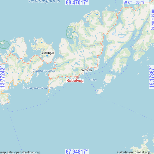
Kabelvåg GPS coordinates[2]
68° 12' 38.376" North, 14° 28' 31.944" East
| Map corner | latitude | longitude |
|---|---|---|
| Upper-left | 68.47017°, | 13.77242° |
| Center: | 68.21066°, | 14.47554° |
| Lower-right: | 67.94817°, | 15.17867° |
| Map W x H: | 58×58 km | = 36×36mi |
| max Lat: | 71.04137° ⇑10.3% North |
| Kabelvåg: | 68.21066° |
| min Lat: | ⇓89.7% South 58.0274° |
| min Long | Kabelvåg | max Long |
| 4.71485° | 14.47554° | 31.11066° |
| W 88.6%⇐ | ⇒11.4% E |
Elevation
Elevation of Kabelvåg is 3 m = 10 ft, and this is 101.2 m = 332 ft below average elevation for this country.
| Max E: |
897 m = 2943 ft | 92.1% |
| Avg. | 104.2 m = 342 ft | |
| Kabelvåg | 3 m = 10 ft | |
Min E: |
1 m = 3 ft | 7.9% |
See also: Norway elevation on elevation.city.
Geographical zone
Kabelvåg is located in North Frigid zone (between North Pole and Arctic Circle). Distance of this North polar circle is 183.1 km =113.8 mi to South.| Distance of | km | miles | from Kabelvåg |
|---|---|---|---|
| North Pole | 2422.7 | 1505.4 | to North |
| Arctic Circle | 183.1 | 113.8 | to South |
| Tropic Cancer | 4978.4 | 3093.4 | to South |
| Equator | 7584.3 | 4712.7 | to South |


Nearby cities:
15 places around Kabelvåg: (largest is in red/bold)
• Ballstad
41.4 km =25.7 mi,  248°
248°
• Evjen
31.2 km =19.4 mi,  281°
281°
• Gravdal
39.5 km =24.5 mi, 254°
• Leinesfjorden
53.4 km =33.2 mi,  155°
155°
• Leknes
36.4 km =22.6 mi,  258°
258°
• Melbu
35.1 km =21.8 mi,  22°
22°
• Oppeid
49 km =30.4 mi,  106°
106°
• Ramberg
53.3 km =33.1 mi, 255°
• Reine
65.3 km =40.6 mi,  241°
241°
• Sigerfjord
64.1 km =39.8 mi,  41°
41°
• Sortland
65.9 km =40.9 mi, 35°
• Stamsund
27.4 km =17 mi, 250°
• Stokmarknes
43.2 km =26.8 mi, 24°
• Straume
53.2 km =33.1 mi,  359°
359°
• Svolvær
4.6 km =2.9 mi,  55°
55°
Sources, notices
• [Note1] Compared only with cities in Norway existing in our database
• [Src1] Map data: © OpenStreetMap contributors (CC-BY-SA)
• [Src2] Other city data from geonames.org with taken over terms of usage.
• [Src3] Geographical zone / Annual Mean Temperature by Robert A. Rohde @ Wikipedia
