Sigerfjord geodata
Sigerfjord (Nordland) is a populated place; located in Norway in Europe/Oslo (GMT+2) time zone. With population of 792 people, there are 359 cities with bigger population in this country. Compared to other cities in Norway, 91.9% of cities are located further ↓South; 90.7% of cities are located further ←West and 69% of cities have higher elevation than Sigerfjord. Note1


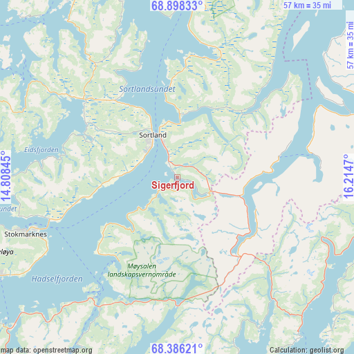
Sigerfjord GPS coordinates[2]
68° 38' 37.428" North, 15° 30' 41.652" East
| Map corner | latitude | longitude |
|---|---|---|
| Upper-left | 68.89833°, | 14.80845° |
| Center: | 68.64373°, | 15.51157° |
| Lower-right: | 68.38621°, | 16.2147° |
| Map W x H: | 56.9×56.9 km | = 35.4×35.4mi |
| max Lat: | 71.04137° ⇑8.1% North |
| Sigerfjord: | 68.64373° |
| min Lat: | ⇓91.9% South 58.0274° |
| min Long | Sigerfjord | max Long |
| 4.71485° | 15.51157° | 31.11066° |
| W 90.7%⇐ | ⇒9.3% E |
Elevation
Elevation of Sigerfjord is 20 m = 66 ft, and this is 84.2 m = 276 ft below average elevation for this country.
| Max E: |
897 m = 2943 ft | 69% |
| Avg. | 104.2 m = 342 ft | |
| Sigerfjord | 20 m = 66 ft | |
Min E: |
1 m = 3 ft | 31% |
See also: Norway elevation on elevation.city.
Geographical zone
Sigerfjord is located in North Frigid zone (between North Pole and Arctic Circle). Distance of this North polar circle is 231.3 km =143.7 mi to South.| Distance of | km | miles | from Sigerfjord |
|---|---|---|---|
| North Pole | 2374.6 | 1475.5 | to North |
| Arctic Circle | 231.3 | 143.7 | to South |
| Tropic Cancer | 5026.5 | 3123.3 | to South |
| Equator | 7632.5 | 4742.6 | to South |


Nearby cities:
15 places around Sigerfjord: (largest is in red/bold)
• Bogen
61.5 km =38.2 mi,  102°
102°
• Borkenes
30.2 km =18.8 mi,  61°
61°
• Evenskjer
43.5 km =27 mi, 98°
• Harstad
45 km =28 mi,  67°
67°
• Hol
37.3 km =23.2 mi,  106°
106°
• Lødingen
32.3 km =20.1 mi,  142°
142°
• Melbu
32.9 km =20.4 mi,  241°
241°
• Myre
34.7 km =21.6 mi,  329°
329°
• Myre
54.5 km =33.9 mi,  19°
19°
• Oppeid
62.2 km =38.6 mi,  176°
176°
• Sortland
7.2 km =4.5 mi,  323°
323°
• Stokmarknes
25.9 km =16.1 mi,  250°
250°
• Strand
6.5 km =4 mi,  337°
337°
• Straume
42.3 km =26.3 mi,  276°
276°
• Svolvær
59.7 km =37.1 mi,  220°
220°
Sources, notices
• [Note1] Compared only with cities in Norway existing in our database
• [Src1] Map data: © OpenStreetMap contributors (CC-BY-SA)
• [Src2] Other city data from geonames.org with taken over terms of usage.
• [Src3] Geographical zone / Annual Mean Temperature by Robert A. Rohde @ Wikipedia
