Stamsund geodata
Stamsund (Nordland) is a populated place; located in Norway in Europe/Oslo (GMT+2) time zone. With population of 999 people, there are 313 cities with bigger population in this country. Compared to other cities in Norway, 89.4% of cities are located further ↓South; 87.2% of cities are located further ←West and 92.1% of cities have higher elevation than Stamsund. Note1


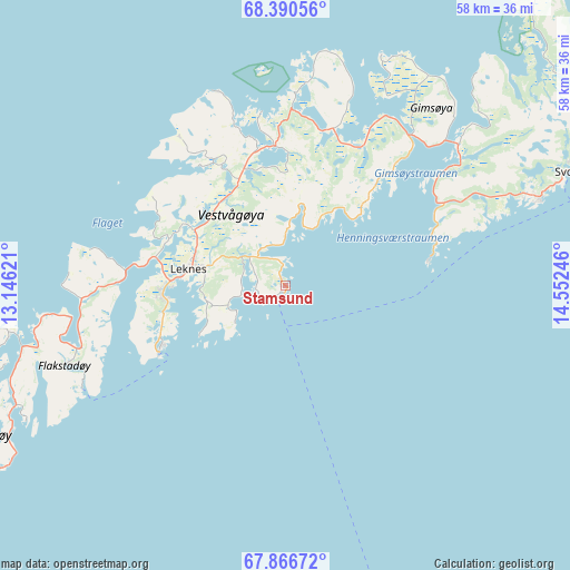
Stamsund GPS coordinates[2]
68° 7' 48.468" North, 13° 50' 57.588" East
| Map corner | latitude | longitude |
|---|---|---|
| Upper-left | 68.39056°, | 13.14621° |
| Center: | 68.13013°, | 13.84933° |
| Lower-right: | 67.86672°, | 14.55246° |
| Map W x H: | 58.2×58.2 km | = 36.2×36.2mi |
| max Lat: | 71.04137° ⇑10.6% North |
| Stamsund: | 68.13013° |
| min Lat: | ⇓89.4% South 58.0274° |
| min Long | Stamsund | max Long |
| 4.71485° | 13.84933° | 31.11066° |
| W 87.2%⇐ | ⇒12.8% E |
Elevation
Elevation of Stamsund is 3 m = 10 ft, and this is 101.2 m = 332 ft below average elevation for this country.
| Max E: |
897 m = 2943 ft | 92.1% |
| Avg. | 104.2 m = 342 ft | |
| Stamsund | 3 m = 10 ft | |
Min E: |
1 m = 3 ft | 7.9% |
See also: Norway elevation on elevation.city.
Geographical zone
Stamsund is located in North Frigid zone (between North Pole and Arctic Circle). Distance of this North polar circle is 174.2 km =108.2 mi to South.| Distance of | km | miles | from Stamsund |
|---|---|---|---|
| North Pole | 2431.7 | 1511 | to North |
| Arctic Circle | 174.2 | 108.2 | to South |
| Tropic Cancer | 4969.4 | 3087.8 | to South |
| Equator | 7575.4 | 4707.1 | to South |


Nearby cities:
15 places around Stamsund: (largest is in red/bold)
• Ballstad
14.1 km =8.8 mi,  243°
243°
• Evjen
15.9 km =9.9 mi,  342°
342°
• Gravdal
12.3 km =7.6 mi,  263°
263°
• Kabelvåg
27.4 km =17 mi,  70°
70°
• Leinesfjorden
62.6 km =38.9 mi,  129°
129°
• Leknes
10 km =6.2 mi,  281°
281°
• Melbu
56.9 km =35.4 mi,  43°
43°
• Oppeid
73.1 km =45.4 mi,  93°
93°
• Ramberg
26.1 km =16.2 mi, 260°
• Reine
38.5 km =23.9 mi, 235°
• Sigerfjord
88.9 km =55.2 mi,  50°
50°
• Stokmarknes
65 km =40.4 mi, 42°
• Straume
67.1 km =41.7 mi,  22°
22°
• Svolvær
31.9 km =19.8 mi, 68°
• Sørland
70.6 km =43.9 mi,  223°
223°
Sources, notices
• [Note1] Compared only with cities in Norway existing in our database
• [Src1] Map data: © OpenStreetMap contributors (CC-BY-SA)
• [Src2] Other city data from geonames.org with taken over terms of usage.
• [Src3] Geographical zone / Annual Mean Temperature by Robert A. Rohde @ Wikipedia
