Stokmarknes geodata
Stokmarknes (Nordland) is a seat of a second-order administrative division; located in Norway in Europe/Oslo (GMT+2) time zone. With population of 3,119 people, there are 129 cities with bigger population in this country. Compared to other cities in Norway, 91.6% of cities are located further ↓South; 89.6% of cities are located further ←West and 100% of cities have higher elevation than Stokmarknes. Note1


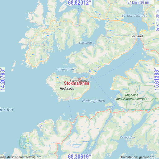
Stokmarknes GPS coordinates[2]
68° 33' 52.632" North, 14° 54' 38.7" East
| Map corner | latitude | longitude |
|---|---|---|
| Upper-left | 68.82012°, | 14.20763° |
| Center: | 68.56462°, | 14.91075° |
| Lower-right: | 68.30619°, | 15.61388° |
| Map W x H: | 57.1×57.1 km | = 35.5×35.5mi |
| max Lat: | 71.04137° ⇑8.4% North |
| Stokmarknes: | 68.56462° |
| min Lat: | ⇓91.6% South 58.0274° |
| min Long | Stokmarknes | max Long |
| 4.71485° | 14.91075° | 31.11066° |
| W 89.6%⇐ | ⇒10.4% E |
Elevation
Elevation of Stokmarknes is 1 m = 3 ft, and this is 103.2 m = 339 ft below average elevation for this country.
| Max E: |
897 m = 2943 ft | 100% |
| Avg. | 104.2 m = 342 ft | |
| Stokmarknes | 1 m = 3 ft | |
Min E: |
1 m = 3 ft | 0% |
See also: Norway elevation on elevation.city.
Geographical zone
Stokmarknes is located in North Frigid zone (between North Pole and Arctic Circle). Distance of this North polar circle is 222.5 km =138.3 mi to South.| Distance of | km | miles | from Stokmarknes |
|---|---|---|---|
| North Pole | 2383.4 | 1481 | to North |
| Arctic Circle | 222.5 | 138.3 | to South |
| Tropic Cancer | 5017.8 | 3117.9 | to South |
| Equator | 7623.7 | 4737.1 | to South |


Nearby cities:
15 places around Stokmarknes: (largest is in red/bold)
• Borkenes
56 km =34.8 mi,  65°
65°
• Evenskjer
67.5 km =41.9 mi,  88°
88°
• Evjen
58.5 km =36.4 mi,  235°
235°
• Hol
60.2 km =37.4 mi, 91°
• Kabelvåg
43.2 km =26.8 mi,  204°
204°
• Lødingen
47.3 km =29.4 mi,  110°
110°
• Melbu
8.3 km =5.2 mi,  213°
213°
• Myre
39.4 km =24.5 mi,  9°
9°
• Oppeid
60.5 km =37.6 mi,  151°
151°
• Sigerfjord
25.9 km =16.1 mi, 70°
• Sortland
24.8 km =15.4 mi,  53°
53°
• Stamsund
65 km =40.4 mi,  222°
222°
• Strand
26.3 km =16.3 mi,  55°
55°
• Straume
22.5 km =14 mi,  307°
307°
• Svolvær
39.3 km =24.4 mi, 200°
Sources, notices
• [Note1] Compared only with cities in Norway existing in our database
• [Src1] Map data: © OpenStreetMap contributors (CC-BY-SA)
• [Src2] Other city data from geonames.org with taken over terms of usage.
• [Src3] Geographical zone / Annual Mean Temperature by Robert A. Rohde @ Wikipedia
