Metetí geodata
Metetí (Darién) is a seat of a third-order administrative division; located in Panama in America/Panama (GMT-5) time zone. With population of 2,298 people, there are 107 cities with bigger population in this country. Compared to other cities in Panama, 52.8% of cities are located further ↓South; 97.4% of cities are located further ←West and 59.3% of cities have higher elevation than Metetí. Note1


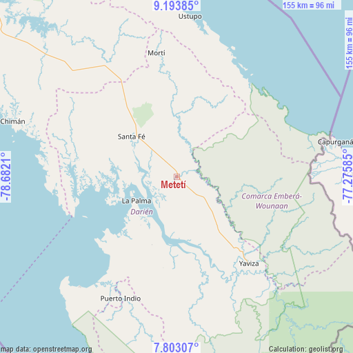
Metetí GPS coordinates[2]
8° 29' 56.724" North, 77° 58' 44.292" West
| Map corner | latitude | longitude |
|---|---|---|
| Upper-left | 9.19385°, | -78.6821° |
| Center: | 8.49909°, | -77.97897° |
| Lower-right: | 7.80307°, | -77.27585° |
| Map W x H: | 154.6×154.6 km | = 96.1×96.1mi |
| max Lat: | 9.60898° ⇑47.2% North |
| Metetí: | 8.49909° |
| min Lat: | ⇓52.8% South 7.26534° |
| min Long | Metetí | max Long |
| -82.91275° | -77.97897° | -77.38965° |
| W 97.4%⇐ | ⇒2.6% E |
Elevation
Elevation of Metetí is 55 m = 180 ft, and this is 117.1 m = 384 ft below average elevation for this country.
| Max E: |
2103 m = 6900 ft | 59.3% |
| Avg. | 172.1 m = 565 ft | |
| Metetí | 55 m = 180 ft | |
Min E: |
-1 m = -3 ft | 40.7% |
See also: Panama elevation on elevation.city.
Geographical zone
Metetí is located in North Torrid zone (between Equator and Tropic of Cancer). Distance of Equator is 945 km =587.2 mi to South.| Distance of | km | miles | from Metetí |
|---|---|---|---|
| North Pole | 9062.1 | 5630.9 | to North |
| Arctic Circle | 6456.2 | 4011.7 | to North |
| Tropic Cancer | 1660.9 | 1032 | to North |
| Equator | 945 | 587.2 | to South |


Nearby cities:
15 places around Metetí: (largest is in red/bold)
• Agua Fría Número Uno
46.6 km =29 mi,  328°
328°
• Barriales
46 km =28.6 mi,  281°
281°
• Chepigana
25 km =15.5 mi,  198°
198°
• Cucunatí
31.7 km =19.7 mi,  285°
285°
• La Palma
20.5 km =12.7 mi,  239°
239°
• Lajas Blancas
20.7 km =12.9 mi,  116°
116°
• Mortí
38.2 km =23.7 mi,  0°
0°
• Mortí
39.9 km =24.8 mi,  9°
9°
• Pueblo Nuevo
48.9 km =30.4 mi,  217°
217°
• Punta Alegre
37.8 km =23.5 mi,  233°
233°
• Quebrada Honda
21.1 km =13.1 mi,  315°
315°
• Santa Fé
26.5 km =16.5 mi,  310°
310°
• Setegantí
26.4 km =16.4 mi,  210°
210°
• Villa Darién
6 km =3.7 mi, 328°
• Zapallal
23.6 km =14.7 mi, 315°
Sources, notices
• [Note1] Compared only with cities in Panama existing in our database
• [Src1] Map data: © OpenStreetMap contributors (CC-BY-SA)
• [Src2] Other city data from geonames.org with taken over terms of usage.
• [Src3] Geographical zone / Annual Mean Temperature by Robert A. Rohde @ Wikipedia
