La Peña geodata
La Peña (Veraguas) is a seat of a third-order administrative division; located in Panama in America/Panama (GMT-5) time zone. With population of 2,223 people, there are 112 cities with bigger population in this country. Compared to other cities in Panama, 75.4% of cities are located further ↑North; 62.3% of cities are located further →East and 63.7% of cities have lower elevation than La Peña. Note1


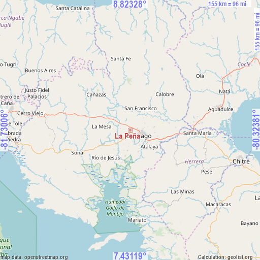
La Peña GPS coordinates[2]
8° 7' 40.224" North, 81° 1' 36.948" West
| Map corner | latitude | longitude |
|---|---|---|
| Upper-left | 8.82328°, | -81.73006° |
| Center: | 8.12784°, | -81.02693° |
| Lower-right: | 7.43119°, | -80.32381° |
| Map W x H: | 154.8×154.8 km | = 96.2×96.2mi |
| max Lat: | 9.60898° ⇑75.4% North |
| La Peña: | 8.12784° |
| min Lat: | ⇓24.6% South 7.26534° |
| min Long | La Peña | max Long |
| -82.91275° | -81.02693° | -77.38965° |
| W 37.7%⇐ | ⇒62.3% E |
Elevation
Elevation of La Peña is 121 m = 397 ft, and this is 51.1 m = 168 ft below average elevation for this country.
| Max E: |
2103 m = 6900 ft | 36.3% |
| Avg. | 172.1 m = 565 ft | |
| La Peña | 121 m = 397 ft | |
Min E: |
-1 m = -3 ft | 63.7% |
See also: Panama elevation on elevation.city.
Geographical zone
La Peña is located in North Torrid zone (between Equator and Tropic of Cancer). Distance of Equator is 903.7 km =561.5 mi to South.| Distance of | km | miles | from La Peña |
|---|---|---|---|
| North Pole | 9103.3 | 5656.5 | to North |
| Arctic Circle | 6497.4 | 4037.3 | to North |
| Tropic Cancer | 1702.2 | 1057.7 | to North |
| Equator | 903.7 | 561.5 | to South |


Nearby cities:
15 places around La Peña: (largest is in red/bold)
• Atalaya
14.7 km =9.1 mi,  130°
130°
• Canto del Llano
7 km =4.3 mi,  92°
92°
• El Espino
10.6 km =6.6 mi,  46°
46°
• El Uvito
4.8 km =3 mi,  105°
105°
• La Colorada
13.5 km =8.4 mi,  160°
160°
• La Soledad
4.1 km =2.5 mi,  77°
77°
• Las Barreras
4.1 km =2.5 mi, 128°
• Llano Grande
13.4 km =8.3 mi,  243°
243°
• Los Algarrobos
2.6 km =1.6 mi,  144°
144°
• Los Remedios
1.4 km =0.9 mi,  12°
12°
• Punta Delgadita
9.3 km =5.8 mi,  102°
102°
• San Antonio
12.1 km =7.5 mi,  120°
120°
• San Francisco
14.4 km =8.9 mi,  23°
23°
• San Pedro del Espino
6.7 km =4.2 mi,  281°
281°
• Santiago de Veraguas
5.7 km =3.5 mi, 122°
Sources, notices
• [Note1] Compared only with cities in Panama existing in our database
• [Src1] Map data: © OpenStreetMap contributors (CC-BY-SA)
• [Src2] Other city data from geonames.org with taken over terms of usage.
• [Src3] Geographical zone / Annual Mean Temperature by Robert A. Rohde @ Wikipedia
