Los Remedios geodata
Los Remedios (Veraguas) is a populated place; located in Panama in America/Panama (GMT-5) time zone. With population of 540 people, there are 449 cities with bigger population in this country. Compared to other cities in Panama, 74.9% of cities are located further ↑North; 62.2% of cities are located further →East and 63.7% of cities have lower elevation than Los Remedios. Note1


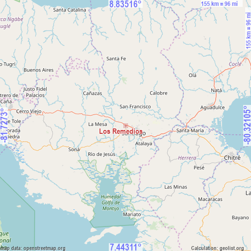
Los Remedios GPS coordinates[2]
8° 8' 23.064" North, 81° 1' 27.012" West
| Map corner | latitude | longitude |
|---|---|---|
| Upper-left | 8.83516°, | -81.7273° |
| Center: | 8.13974°, | -81.02417° |
| Lower-right: | 7.44311°, | -80.32105° |
| Map W x H: | 154.8×154.8 km | = 96.2×96.2mi |
| max Lat: | 9.60898° ⇑74.9% North |
| Los Remedios: | 8.13974° |
| min Lat: | ⇓25.1% South 7.26534° |
| min Long | Los Remedios | max Long |
| -82.91275° | -81.02417° | -77.38965° |
| W 37.8%⇐ | ⇒62.2% E |
Elevation
Elevation of Los Remedios is 121 m = 397 ft, and this is 51.1 m = 168 ft below average elevation for this country.
| Max E: |
2103 m = 6900 ft | 36.3% |
| Avg. | 172.1 m = 565 ft | |
| Los Remedios | 121 m = 397 ft | |
Min E: |
-1 m = -3 ft | 63.7% |
See also: Panama elevation on elevation.city.
Geographical zone
Los Remedios is located in North Torrid zone (between Equator and Tropic of Cancer). Distance of Equator is 905.1 km =562.4 mi to South.| Distance of | km | miles | from Los Remedios |
|---|---|---|---|
| North Pole | 9102 | 5655.7 | to North |
| Arctic Circle | 6496.1 | 4036.5 | to North |
| Tropic Cancer | 1700.9 | 1056.9 | to North |
| Equator | 905.1 | 562.4 | to South |


Nearby cities:
15 places around Los Remedios: (largest is in red/bold)
• Calabacito
13.6 km =8.5 mi,  332°
332°
• Canto del Llano
6.9 km =4.3 mi,  104°
104°
• El Espino
9.5 km =5.9 mi,  50°
50°
• El Uvito
5.1 km =3.2 mi,  120°
120°
• La Colorada
14.7 km =9.1 mi,  163°
163°
• La Peña
1.4 km =0.9 mi,  192°
192°
• La Soledad
3.7 km =2.3 mi, 97°
• Las Barreras
4.9 km =3 mi,  142°
142°
• Llano Grande
14.3 km =8.9 mi,  239°
239°
• Los Algarrobos
3.6 km =2.2 mi, 161°
• Punta Delgadita
9.4 km =5.8 mi,  111°
111°
• San Antonio
12.6 km =7.8 mi,  126°
126°
• San Francisco
13.1 km =8.1 mi,  24°
24°
• San Pedro del Espino
6.9 km =4.3 mi,  270°
270°
• Santiago de Veraguas
6.3 km =3.9 mi, 134°
Sources, notices
• [Note1] Compared only with cities in Panama existing in our database
• [Src1] Map data: © OpenStreetMap contributors (CC-BY-SA)
• [Src2] Other city data from geonames.org with taken over terms of usage.
• [Src3] Geographical zone / Annual Mean Temperature by Robert A. Rohde @ Wikipedia
