Peña Blanca geodata
Peña Blanca (Ngöbe-Buglé) is a seat of a third-order administrative division; located in Panama in America/Panama (GMT-5) time zone. In our database, there are 694 cities with bigger population. Compared to other cities in Panama, 51.5% of cities are located further ↑North; 72.7% of cities are located further →East and 96.3% of cities have lower elevation than Peña Blanca. Note1


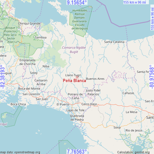
Peña Blanca GPS coordinates[2]
8° 27' 42.156" North, 81° 40' 43.68" West
| Map corner | latitude | longitude |
|---|---|---|
| Upper-left | 9.15654°, | -82.38193° |
| Center: | 8.46171°, | -81.6788° |
| Lower-right: | 7.76563°, | -80.97568° |
| Map W x H: | 154.7×154.7 km | = 96.1×96.1mi |
| max Lat: | 9.60898° ⇑51.5% North |
| Peña Blanca: | 8.46171° |
| min Lat: | ⇓48.5% South 7.26534° |
| min Long | Peña Blanca | max Long |
| -82.91275° | -81.6788° | -77.38965° |
| W 27.3%⇐ | ⇒72.7% E |
Elevation
Elevation of Peña Blanca is 839 m = 2753 ft, and this is 666.9 m = 2188 ft above average elevation for this country.
| Max E: |
2103 m = 6900 ft | 3.7% |
| Peña Blanca | 839 m 2753 ft | |
| Avg. | 172.1 m = 565 ft | |
Min E: |
-1 m = -3 ft | 96.3% |
See also: Panama elevation on elevation.city.
Geographical zone
Peña Blanca is located in North Torrid zone (between Equator and Tropic of Cancer). Distance of Equator is 940.9 km =584.6 mi to South.| Distance of | km | miles | from Peña Blanca |
|---|---|---|---|
| North Pole | 9066.2 | 5633.5 | to North |
| Arctic Circle | 6460.3 | 4014.2 | to North |
| Tropic Cancer | 1665.1 | 1034.6 | to North |
| Equator | 940.9 | 584.6 | to South |


Nearby cities:
15 places around Peña Blanca: (largest is in red/bold)
• Buabidi
2.6 km =1.6 mi,  303°
303°
• Cerro Caña
14.4 km =8.9 mi,  148°
148°
• Cerro Mosquito
12.7 km =7.9 mi,  185°
185°
• Cerro Plata
14.7 km =9.1 mi,  83°
83°
• Chichica
10.7 km =6.6 mi,  172°
172°
• Chichica
11.5 km =7.1 mi, 172°
• Hato Chami
10.5 km =6.5 mi,  258°
258°
• Llano Ñopo
8.1 km =5 mi,  125°
125°
• Maraca
11.2 km =7 mi,  208°
208°
• Mirones
11.8 km =7.3 mi,  334°
334°
• Peña Prieta
11 km =6.8 mi,  202°
202°
• Piedra Roja
14.2 km =8.8 mi, 328°
• Quebrada Canoa
11.9 km =7.4 mi,  254°
254°
• Sitio Prado
14.6 km =9.1 mi, 132°
• Tebujo
9.4 km =5.8 mi, 209°
Sources, notices
• [Note1] Compared only with cities in Panama existing in our database
• [Src1] Map data: © OpenStreetMap contributors (CC-BY-SA)
• [Src2] Other city data from geonames.org with taken over terms of usage.
• [Src3] Geographical zone / Annual Mean Temperature by Robert A. Rohde @ Wikipedia
