Llano Ñopo geodata
Llano Ñopo (Ngöbe-Buglé) is a seat of a third-order administrative division; located in Panama in America/Panama (GMT-5) time zone. With population of 289 people, there are 561 cities with bigger population in this country. Compared to other cities in Panama, 55.9% of cities are located further ↑North; 71.5% of cities are located further →East and 85.5% of cities have lower elevation than Llano Ñopo. Note1


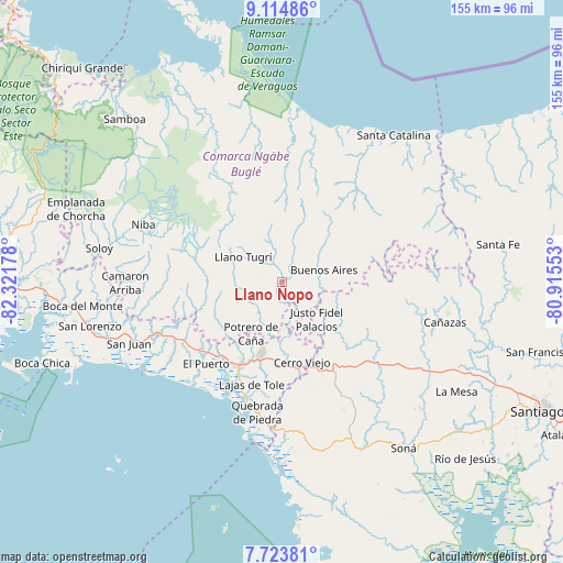
Llano Ñopo GPS coordinates[2]
8° 25' 11.856" North, 81° 37' 7.14" West
| Map corner | latitude | longitude |
|---|---|---|
| Upper-left | 9.11486°, | -82.32178° |
| Center: | 8.41996°, | -81.61865° |
| Lower-right: | 7.72381°, | -80.91553° |
| Map W x H: | 154.7×154.7 km | = 96.1×96.1mi |
| max Lat: | 9.60898° ⇑55.9% North |
| Llano Ñopo: | 8.41996° |
| min Lat: | ⇓44.1% South 7.26534° |
| min Long | Llano Ñopo | max Long |
| -82.91275° | -81.61865° | -77.38965° |
| W 28.5%⇐ | ⇒71.5% E |
Elevation
Elevation of Llano Ñopo is 342 m = 1122 ft, and this is 169.9 m = 557 ft above average elevation for this country.
| Max E: |
2103 m = 6900 ft | 14.5% |
| Llano Ñopo | 342 m 1122 ft | |
| Avg. | 172.1 m = 565 ft | |
Min E: |
-1 m = -3 ft | 85.5% |
See also: Panama elevation on elevation.city.
Geographical zone
Llano Ñopo is located in North Torrid zone (between Equator and Tropic of Cancer). Distance of Equator is 936.2 km =581.7 mi to South.| Distance of | km | miles | from Llano Ñopo |
|---|---|---|---|
| North Pole | 9070.9 | 5636.4 | to North |
| Arctic Circle | 6465 | 4017.2 | to North |
| Tropic Cancer | 1669.7 | 1037.5 | to North |
| Equator | 936.2 | 581.7 | to South |


Nearby cities:
15 places around Llano Ñopo: (largest is in red/bold)
• Alto Caballero
15.7 km =9.8 mi,  202°
202°
• Bajo Solis
12.7 km =7.9 mi,  129°
129°
• Buabidi
10.7 km =6.6 mi,  304°
304°
• Buenos Aires
14.8 km =9.2 mi,  92°
92°
• Cerro Caña
7.6 km =4.7 mi,  173°
173°
• Cerro Iglesias
12.7 km =7.9 mi,  151°
151°
• Cerro Mosquito
11.2 km =7 mi,  224°
224°
• Cerro Plata
10.2 km =6.3 mi,  51°
51°
• Chichica
7.9 km =4.9 mi, 221°
• Chichica
8.5 km =5.3 mi, 217°
• Maraca
13.1 km =8.1 mi,  246°
246°
• Peña Blanca
8.1 km =5 mi,  305°
305°
• Peña Prieta
12.1 km =7.5 mi,  243°
243°
• Sitio Prado
6.7 km =4.2 mi,  142°
142°
• Tebujo
11.9 km =7.4 mi, 252°
Sources, notices
• [Note1] Compared only with cities in Panama existing in our database
• [Src1] Map data: © OpenStreetMap contributors (CC-BY-SA)
• [Src2] Other city data from geonames.org with taken over terms of usage.
• [Src3] Geographical zone / Annual Mean Temperature by Robert A. Rohde @ Wikipedia
