Cerro Plata geodata
Cerro Plata (Ngöbe-Buglé) is a seat of a third-order administrative division; located in Panama in America/Panama (GMT-5) time zone. With population of 162 people, there are 624 cities with bigger population in this country. Compared to other cities in Panama, 50.9% of cities are located further ↓South; 70.5% of cities are located further →East and 96.5% of cities have lower elevation than Cerro Plata. Note1


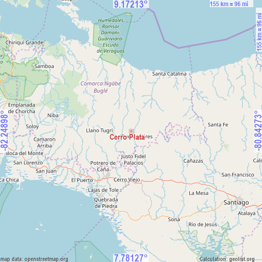
Cerro Plata GPS coordinates[2]
8° 28' 38.388" North, 81° 32' 45.06" West
| Map corner | latitude | longitude |
|---|---|---|
| Upper-left | 9.17213°, | -82.24898° |
| Center: | 8.47733°, | -81.54585° |
| Lower-right: | 7.78127°, | -80.84273° |
| Map W x H: | 154.6×154.7 km | = 96.1×96.1mi |
| max Lat: | 9.60898° ⇑49.1% North |
| Cerro Plata: | 8.47733° |
| min Lat: | ⇓50.9% South 7.26534° |
| min Long | Cerro Plata | max Long |
| -82.91275° | -81.54585° | -77.38965° |
| W 29.5%⇐ | ⇒70.5% E |
Elevation
Elevation of Cerro Plata is 845 m = 2772 ft, and this is 672.9 m = 2208 ft above average elevation for this country.
| Max E: |
2103 m = 6900 ft | 3.5% |
| Cerro Plata | 845 m 2772 ft | |
| Avg. | 172.1 m = 565 ft | |
Min E: |
-1 m = -3 ft | 96.5% |
See also: Panama elevation on elevation.city.
Geographical zone
Cerro Plata is located in North Torrid zone (between Equator and Tropic of Cancer). Distance of Equator is 942.6 km =585.7 mi to South.| Distance of | km | miles | from Cerro Plata |
|---|---|---|---|
| North Pole | 9064.5 | 5632.4 | to North |
| Arctic Circle | 6458.6 | 4013.2 | to North |
| Tropic Cancer | 1663.3 | 1033.5 | to North |
| Equator | 942.6 | 585.7 | to South |


Nearby cities:
15 places around Cerro Plata: (largest is in red/bold)
• Agua de Salud
9.5 km =5.9 mi,  71°
71°
• Bajo Solis
14.6 km =9.1 mi,  172°
172°
• Buabidi
16.8 km =10.4 mi,  268°
268°
• Buenos Aires
9.8 km =6.1 mi,  136°
136°
• Cerro Caña
15.7 km =9.8 mi,  206°
206°
• Cerro Iglesias
17.7 km =11 mi,  186°
186°
• Chichica
18.1 km =11.2 mi,  227°
227°
• Chichica
18.6 km =11.6 mi, 225°
• Guayabito
9.8 km =6.1 mi,  45°
45°
• Güibale
20.5 km =12.7 mi,  79°
79°
• Llano Ñopo
10.2 km =6.3 mi, 231°
• Peña Blanca
14.7 km =9.1 mi,  263°
263°
• San José
19.4 km =12.1 mi,  126°
126°
• Sitio Prado
12.3 km =7.6 mi,  198°
198°
• Viguí
16.2 km =10.1 mi,  161°
161°
Sources, notices
• [Note1] Compared only with cities in Panama existing in our database
• [Src1] Map data: © OpenStreetMap contributors (CC-BY-SA)
• [Src2] Other city data from geonames.org with taken over terms of usage.
• [Src3] Geographical zone / Annual Mean Temperature by Robert A. Rohde @ Wikipedia
