Pedregal geodata
Pedregal (Chiriquí) is a seat of a third-order administrative division; located in Panama in America/Panama (GMT-5) time zone. With population of 17,427 people, there are 22 cities with bigger population in this country. Compared to other cities in Panama, 61.3% of cities are located further ↑North; 86.3% of cities are located further →East and 98.6% of cities have higher elevation than Pedregal. Note1


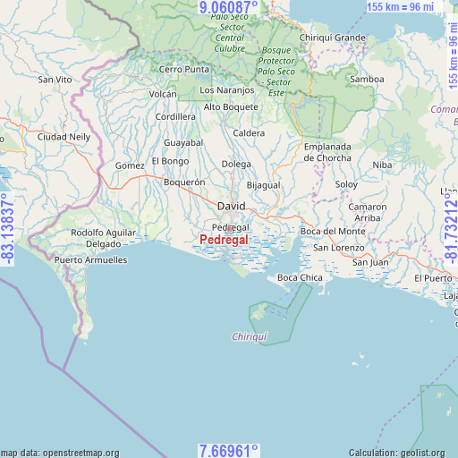
Pedregal GPS coordinates[2]
8° 21' 57.096" North, 82° 26' 6.864" West
| Map corner | latitude | longitude |
|---|---|---|
| Upper-left | 9.06087°, | -83.13837° |
| Center: | 8.36586°, | -82.43524° |
| Lower-right: | 7.66961°, | -81.73212° |
| Map W x H: | 154.7×154.7 km | = 96.1×96.1mi |
| max Lat: | 9.60898° ⇑61.3% North |
| Pedregal: | 8.36586° |
| min Lat: | ⇓38.7% South 7.26534° |
| min Long | Pedregal | max Long |
| -82.91275° | -82.43524° | -77.38965° |
| W 13.7%⇐ | ⇒86.3% E |
Elevation
Elevation of Pedregal is 4 m = 13 ft, and this is 168.1 m = 552 ft below average elevation for this country.
| Max E: |
2103 m = 6900 ft | 98.6% |
| Avg. | 172.1 m = 565 ft | |
| Pedregal | 4 m = 13 ft | |
Min E: |
-1 m = -3 ft | 1.4% |
See also: Panama elevation on elevation.city.
Geographical zone
Pedregal is located in North Torrid zone (between Equator and Tropic of Cancer). Distance of Equator is 930.2 km =578 mi to South.| Distance of | km | miles | from Pedregal |
|---|---|---|---|
| North Pole | 9076.9 | 5640.1 | to North |
| Arctic Circle | 6471 | 4020.9 | to North |
| Tropic Cancer | 1675.7 | 1041.2 | to North |
| Equator | 930.2 | 578 | to South |


Nearby cities:
15 places around Pedregal: (largest is in red/bold)
• Aguacatal
10.8 km =6.7 mi,  348°
348°
• Chiriquí
13 km =8.1 mi,  76°
76°
• David
6.8 km =4.2 mi,  4°
4°
• Guarumal
10.9 km =6.8 mi,  257°
257°
• Las Lomas
8.8 km =5.5 mi,  36°
36°
• Mata del Nance
10.2 km =6.3 mi,  22°
22°
• Montilla
11.9 km =7.4 mi,  336°
336°
• Nuevo San Carlitos
10.1 km =6.3 mi,  358°
358°
• Orillas del Río
8 km =5 mi,  266°
266°
• Portachuelo
12 km =7.5 mi,  8°
8°
• Querévalo
10.1 km =6.3 mi, 273°
• Quinteño
12.6 km =7.8 mi, 21°
• San Carlitos
13.3 km =8.3 mi, 352°
• San Pablo Nuevo Abajo
9.9 km =6.2 mi,  312°
312°
• San Pablo Viejo Abajo
12.2 km =7.6 mi,  323°
323°
Sources, notices
• [Note1] Compared only with cities in Panama existing in our database
• [Src1] Map data: © OpenStreetMap contributors (CC-BY-SA)
• [Src2] Other city data from geonames.org with taken over terms of usage.
• [Src3] Geographical zone / Annual Mean Temperature by Robert A. Rohde @ Wikipedia
