Mata del Nance geodata
Mata del Nance (Chiriquí) is a populated place; located in Panama in America/Panama (GMT-5) time zone. With population of 1,051 people, there are 241 cities with bigger population in this country. Compared to other cities in Panama, 53% of cities are located further ↑North; 84.1% of cities are located further →East and 53.5% of cities have lower elevation than Mata del Nance. Note1


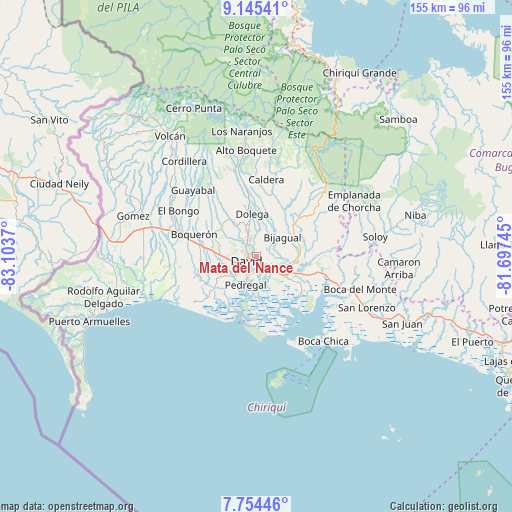
Mata del Nance GPS coordinates[2]
8° 27' 2.016" North, 82° 24' 2.052" West
| Map corner | latitude | longitude |
|---|---|---|
| Upper-left | 9.14541°, | -83.1037° |
| Center: | 8.45056°, | -82.40057° |
| Lower-right: | 7.75446°, | -81.69745° |
| Map W x H: | 154.7×154.7 km | = 96.1×96.1mi |
| max Lat: | 9.60898° ⇑53% North |
| Mata del Nance: | 8.45056° |
| min Lat: | ⇓47% South 7.26534° |
| min Long | Mata del Nance | max Long |
| -82.91275° | -82.40057° | -77.38965° |
| W 15.9%⇐ | ⇒84.1% E |
Elevation
Elevation of Mata del Nance is 83 m = 272 ft, and this is 89.1 m = 292 ft below average elevation for this country.
| Max E: |
2103 m = 6900 ft | 46.5% |
| Avg. | 172.1 m = 565 ft | |
| Mata del Nance | 83 m = 272 ft | |
Min E: |
-1 m = -3 ft | 53.5% |
See also: Panama elevation on elevation.city.
Geographical zone
Mata del Nance is located in North Torrid zone (between Equator and Tropic of Cancer). Distance of Equator is 939.6 km =583.8 mi to South.| Distance of | km | miles | from Mata del Nance |
|---|---|---|---|
| North Pole | 9067.4 | 5634.2 | to North |
| Arctic Circle | 6461.6 | 4015.1 | to North |
| Tropic Cancer | 1666.3 | 1035.4 | to North |
| Equator | 939.6 | 583.8 | to South |


Nearby cities:
15 places around Mata del Nance: (largest is in red/bold)
• Aguacatal
6.2 km =3.9 mi,  280°
280°
• Algarrobos Arriba
7.6 km =4.7 mi,  341°
341°
• Cochea Abajo
7.6 km =4.7 mi,  37°
37°
• David
4.2 km =2.6 mi,  232°
232°
• Dos Ríos Abajo
8.8 km =5.5 mi,  9°
9°
• Guayabal
4.9 km =3 mi,  74°
74°
• Las Lomas
2.8 km =1.7 mi,  148°
148°
• Los Algarrobos
5.7 km =3.5 mi,  332°
332°
• Los Anastacios
9.2 km =5.7 mi, 344°
• Montilla
8.8 km =5.5 mi, 279°
• Nuevo San Carlitos
4.1 km =2.5 mi, 280°
• Portachuelo
3.2 km =2 mi,  320°
320°
• Quinteño
2.4 km =1.5 mi,  18°
18°
• Rincón Largo
7.8 km =4.8 mi,  355°
355°
• San Carlitos
6.7 km =4.2 mi,  304°
304°
Sources, notices
• [Note1] Compared only with cities in Panama existing in our database
• [Src1] Map data: © OpenStreetMap contributors (CC-BY-SA)
• [Src2] Other city data from geonames.org with taken over terms of usage.
• [Src3] Geographical zone / Annual Mean Temperature by Robert A. Rohde @ Wikipedia
