Chiriquí geodata
Chiriquí is a seat of a third-order administrative division; located in Panama in America/Panama (GMT-5) time zone. With population of 2,429 people, there are 103 cities with bigger population in this country. Compared to other cities in Panama, 58.2% of cities are located further ↑North; 82.6% of cities are located further →East and 69.8% of cities have higher elevation than Chiriquí. Note1


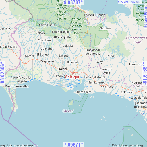
Chiriquí GPS coordinates[2]
8° 23' 34.476" North, 82° 19' 11.748" West
| Map corner | latitude | longitude |
|---|---|---|
| Upper-left | 9.08787°, | -83.02306° |
| Center: | 8.39291°, | -82.31993° |
| Lower-right: | 7.69671°, | -81.61681° |
| Map W x H: | 154.7×154.7 km | = 96.1×96.1mi |
| max Lat: | 9.60898° ⇑58.2% North |
| Chiriquí: | 8.39291° |
| min Lat: | ⇓41.8% South 7.26534° |
| min Long | Chiriquí | max Long |
| -82.91275° | -82.31993° | -77.38965° |
| W 17.4%⇐ | ⇒82.6% E |
Elevation
Elevation of Chiriquí is 36 m = 118 ft, and this is 136.1 m = 447 ft below average elevation for this country.
| Max E: |
2103 m = 6900 ft | 69.8% |
| Avg. | 172.1 m = 565 ft | |
| Chiriquí | 36 m = 118 ft | |
Min E: |
-1 m = -3 ft | 30.2% |
See also: Panama elevation on elevation.city.
Geographical zone
Chiriquí is located in North Torrid zone (between Equator and Tropic of Cancer). Distance of Equator is 933.2 km =579.9 mi to South.| Distance of | km | miles | from Chiriquí |
|---|---|---|---|
| North Pole | 9073.9 | 5638.3 | to North |
| Arctic Circle | 6468 | 4019 | to North |
| Tropic Cancer | 1672.7 | 1039.4 | to North |
| Equator | 933.2 | 579.9 | to South |


Nearby cities:
15 places around Chiriquí: (largest is in red/bold)
• Aguacatal
16.7 km =10.4 mi,  296°
296°
• Bijagual
13.6 km =8.5 mi,  353°
353°
• Cochea Abajo
13.2 km =8.2 mi,  341°
341°
• David
12.8 km =8 mi,  287°
287°
• Dos Ríos Abajo
16.8 km =10.4 mi,  333°
333°
• Gualaca
15.4 km =9.6 mi,  8°
8°
• Guayabal
8.7 km =5.4 mi, 331°
• Las Lomas
8.5 km =5.3 mi, 298°
• Los Algarrobos
16.2 km =10.1 mi,  314°
314°
• Mata del Nance
10.9 km =6.8 mi, 305°
• Nuevo San Carlitos
14.7 km =9.1 mi, 298°
• Pedregal
13 km =8.1 mi,  256°
256°
• Portachuelo
14.1 km =8.8 mi, 309°
• Quinteño
11.9 km =7.4 mi,  317°
317°
• Rincón
9 km =5.6 mi,  29°
29°
Sources, notices
• [Note1] Compared only with cities in Panama existing in our database
• [Src1] Map data: © OpenStreetMap contributors (CC-BY-SA)
• [Src2] Other city data from geonames.org with taken over terms of usage.
• [Src3] Geographical zone / Annual Mean Temperature by Robert A. Rohde @ Wikipedia
