Las Lomas geodata
Las Lomas (Chiriquí) is a seat of a third-order administrative division; located in Panama in America/Panama (GMT-5) time zone. With population of 11,726 people, there are 36 cities with bigger population in this country. Compared to other cities in Panama, 55% of cities are located further ↑North; 83.8% of cities are located further →East and 52.4% of cities have higher elevation than Las Lomas. Note1


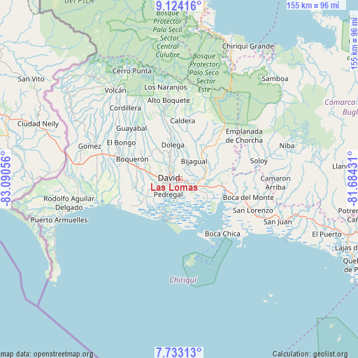
Las Lomas GPS coordinates[2]
8° 25' 45.372" North, 82° 23' 14.748" West
| Map corner | latitude | longitude |
|---|---|---|
| Upper-left | 9.12416°, | -83.09056° |
| Center: | 8.42927°, | -82.38743° |
| Lower-right: | 7.73313°, | -81.68431° |
| Map W x H: | 154.7×154.7 km | = 96.1×96.1mi |
| max Lat: | 9.60898° ⇑55% North |
| Las Lomas: | 8.42927° |
| min Lat: | ⇓45% South 7.26534° |
| min Long | Las Lomas | max Long |
| -82.91275° | -82.38743° | -77.38965° |
| W 16.2%⇐ | ⇒83.8% E |
Elevation
Elevation of Las Lomas is 68 m = 223 ft, and this is 104.1 m = 342 ft below average elevation for this country.
| Max E: |
2103 m = 6900 ft | 52.4% |
| Avg. | 172.1 m = 565 ft | |
| Las Lomas | 68 m = 223 ft | |
Min E: |
-1 m = -3 ft | 47.6% |
See also: Panama elevation on elevation.city.
Geographical zone
Las Lomas is located in North Torrid zone (between Equator and Tropic of Cancer). Distance of Equator is 937.2 km =582.3 mi to South.| Distance of | km | miles | from Las Lomas |
|---|---|---|---|
| North Pole | 9069.8 | 5635.7 | to North |
| Arctic Circle | 6463.9 | 4016.5 | to North |
| Tropic Cancer | 1668.7 | 1036.9 | to North |
| Equator | 937.2 | 582.3 | to South |


Nearby cities:
15 places around Las Lomas: (largest is in red/bold)
• Aguacatal
8.3 km =5.2 mi,  295°
295°
• Algarrobos Arriba
10.3 km =6.4 mi,  338°
338°
• Chiriquí
8.5 km =5.3 mi,  118°
118°
• Cochea Abajo
9 km =5.6 mi,  20°
20°
• David
4.8 km =3 mi,  267°
267°
• Guayabal
4.9 km =3 mi,  42°
42°
• Los Algarrobos
8.4 km =5.2 mi,  331°
331°
• Mata del Nance
2.8 km =1.7 mi, 328°
• Montilla
10.8 km =6.7 mi,  290°
290°
• Nuevo San Carlitos
6.3 km =3.9 mi, 299°
• Pedregal
8.8 km =5.5 mi,  216°
216°
• Portachuelo
6 km =3.7 mi,  324°
324°
• Quinteño
4.7 km =2.9 mi,  351°
351°
• Rincón Largo
10.4 km =6.5 mi, 348°
• San Carlitos
9.3 km =5.8 mi,  311°
311°
Sources, notices
• [Note1] Compared only with cities in Panama existing in our database
• [Src1] Map data: © OpenStreetMap contributors (CC-BY-SA)
• [Src2] Other city data from geonames.org with taken over terms of usage.
• [Src3] Geographical zone / Annual Mean Temperature by Robert A. Rohde @ Wikipedia
