París geodata
París (Herrera) is a seat of a third-order administrative division; located in Panama in America/Panama (GMT-5) time zone. With population of 894 people, there are 284 cities with bigger population in this country. Compared to other cities in Panama, 79% of cities are located further ↑North; 51.3% of cities are located further ←West and 78.5% of cities have higher elevation than París. Note1


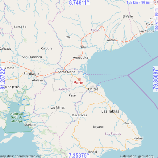
París GPS coordinates[2]
8° 3' 1.908" North, 80° 33' 14.724" West
| Map corner | latitude | longitude |
|---|---|---|
| Upper-left | 8.74611°, | -81.25722° |
| Center: | 8.05053°, | -80.55409° |
| Lower-right: | 7.35375°, | -79.85097° |
| Map W x H: | 154.8×154.8 km | = 96.2×96.2mi |
| max Lat: | 9.60898° ⇑79% North |
| París: | 8.05053° |
| min Lat: | ⇓21% South 7.26534° |
| min Long | París | max Long |
| -82.91275° | -80.55409° | -77.38965° |
| W 51.3%⇐ | ⇒48.7% E |
Elevation
Elevation of París is 25 m = 82 ft, and this is 147.1 m = 483 ft below average elevation for this country.
| Max E: |
2103 m = 6900 ft | 78.5% |
| Avg. | 172.1 m = 565 ft | |
| París | 25 m = 82 ft | |
Min E: |
-1 m = -3 ft | 21.5% |
See also: Panama elevation on elevation.city.
Geographical zone
París is located in North Torrid zone (between Equator and Tropic of Cancer). Distance of Equator is 895.1 km =556.2 mi to South.| Distance of | km | miles | from París |
|---|---|---|---|
| North Pole | 9111.9 | 5661.9 | to North |
| Arctic Circle | 6506 | 4042.6 | to North |
| Tropic Cancer | 1710.8 | 1063 | to North |
| Equator | 895.1 | 556.2 | to South |


Nearby cities:
15 places around París: (largest is in red/bold)
• Boca de Parita
12.1 km =7.5 mi,  113°
113°
• Cabuya
8.9 km =5.5 mi,  256°
256°
• El Barrero
13.8 km =8.6 mi,  161°
161°
• El Pedregoso
15.7 km =9.8 mi,  216°
216°
• El Pájaro
12 km =7.5 mi,  188°
188°
• El Rincón
10.3 km =6.4 mi,  317°
317°
• La Arena
13.4 km =8.3 mi,  133°
133°
• Llano de La Cruz
14.7 km =9.1 mi, 221°
• Los Castillos
10.1 km =6.3 mi, 224°
• Los Hatillos
13.5 km =8.4 mi,  172°
172°
• Monagrillo
14.9 km =9.3 mi,  120°
120°
• Parita
7.3 km =4.5 mi,  149°
149°
• Portobelillo
5.9 km =3.7 mi,  230°
230°
• Potuga
7.7 km =4.8 mi,  280°
280°
• Santa María
14 km =8.7 mi,  298°
298°
Sources, notices
• [Note1] Compared only with cities in Panama existing in our database
• [Src1] Map data: © OpenStreetMap contributors (CC-BY-SA)
• [Src2] Other city data from geonames.org with taken over terms of usage.
• [Src3] Geographical zone / Annual Mean Temperature by Robert A. Rohde @ Wikipedia
