Los Castillos geodata
Los Castillos (Herrera) is a seat of a third-order administrative division; located in Panama in America/Panama (GMT-5) time zone. With population of 400 people, there are 518 cities with bigger population in this country. Compared to other cities in Panama, 82% of cities are located further ↑North; 51.4% of cities are located further →East and 60.2% of cities have higher elevation than Los Castillos. Note1


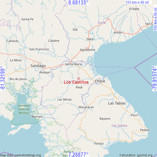
Los Castillos GPS coordinates[2]
7° 59' 8.34" North, 80° 37' 7.896" West
| Map corner | latitude | longitude |
|---|---|---|
| Upper-left | 8.68135°, | -81.32199° |
| Center: | 7.98565°, | -80.61886° |
| Lower-right: | 7.28877°, | -79.91574° |
| Map W x H: | 154.8×154.8 km | = 96.2×96.2mi |
| max Lat: | 9.60898° ⇑82% North |
| Los Castillos: | 7.98565° |
| min Lat: | ⇓18% South 7.26534° |
| min Long | Los Castillos | max Long |
| -82.91275° | -80.61886° | -77.38965° |
| W 48.6%⇐ | ⇒51.4% E |
Elevation
Elevation of Los Castillos is 52 m = 171 ft, and this is 120.1 m = 394 ft below average elevation for this country.
| Max E: |
2103 m = 6900 ft | 60.2% |
| Avg. | 172.1 m = 565 ft | |
| Los Castillos | 52 m = 171 ft | |
Min E: |
-1 m = -3 ft | 39.8% |
See also: Panama elevation on elevation.city.
Geographical zone
Los Castillos is located in North Torrid zone (between Equator and Tropic of Cancer). Distance of Equator is 887.9 km =551.7 mi to South.| Distance of | km | miles | from Los Castillos |
|---|---|---|---|
| North Pole | 9119.1 | 5666.3 | to North |
| Arctic Circle | 6513.3 | 4047.2 | to North |
| Tropic Cancer | 1718 | 1067.5 | to North |
| Equator | 887.9 | 551.7 | to South |


Nearby cities:
15 places around Los Castillos: (largest is in red/bold)
• Cabuya
5.3 km =3.3 mi,  343°
343°
• El Barrero
13 km =8.1 mi,  116°
116°
• El Pedregoso
5.9 km =3.7 mi,  201°
201°
• El Pájaro
7.1 km =4.4 mi,  131°
131°
• La Trinidad
12.2 km =7.6 mi,  229°
229°
• Las Cabras
14.4 km =8.9 mi,  147°
147°
• Llano Grande
10.2 km =6.3 mi,  262°
262°
• Llano de La Cruz
4.6 km =2.9 mi,  214°
214°
• Los Hatillos
10.8 km =6.7 mi, 124°
• Parita
10.8 km =6.7 mi,  85°
85°
• París
10.1 km =6.3 mi,  44°
44°
• Pesé
8.6 km =5.3 mi,  176°
176°
• Portobelillo
4.4 km =2.7 mi, 36°
• Potuga
8.6 km =5.3 mi,  357°
357°
• Sabana Grande
11.9 km =7.4 mi,  190°
190°
Sources, notices
• [Note1] Compared only with cities in Panama existing in our database
• [Src1] Map data: © OpenStreetMap contributors (CC-BY-SA)
• [Src2] Other city data from geonames.org with taken over terms of usage.
• [Src3] Geographical zone / Annual Mean Temperature by Robert A. Rohde @ Wikipedia
