Cabuya geodata
Cabuya (Herrera) is a seat of a third-order administrative division; located in Panama in America/Panama (GMT-5) time zone. With population of 417 people, there are 512 cities with bigger population in this country. Compared to other cities in Panama, 79.8% of cities are located further ↑North; 52% of cities are located further →East and 61.3% of cities have higher elevation than Cabuya. Note1


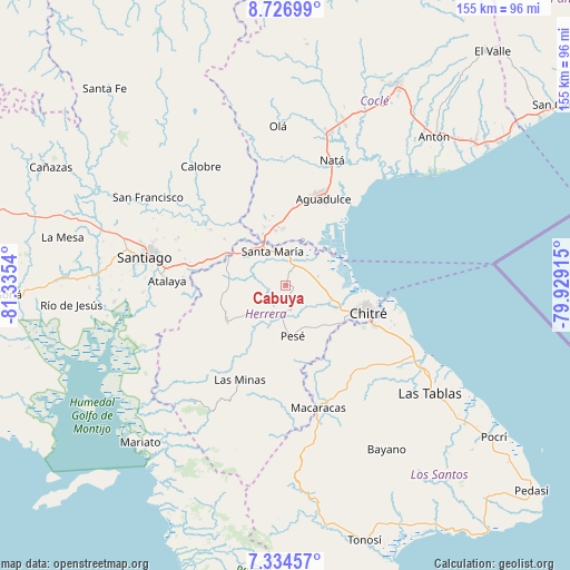
Cabuya GPS coordinates[2]
8° 1' 52.968" North, 80° 37' 56.172" West
| Map corner | latitude | longitude |
|---|---|---|
| Upper-left | 8.72699°, | -81.3354° |
| Center: | 8.03138°, | -80.63227° |
| Lower-right: | 7.33457°, | -79.92915° |
| Map W x H: | 154.8×154.8 km | = 96.2×96.2mi |
| max Lat: | 9.60898° ⇑79.8% North |
| Cabuya: | 8.03138° |
| min Lat: | ⇓20.2% South 7.26534° |
| min Long | Cabuya | max Long |
| -82.91275° | -80.63227° | -77.38965° |
| W 48%⇐ | ⇒52% E |
Elevation
Elevation of Cabuya is 50 m = 164 ft, and this is 122.1 m = 401 ft below average elevation for this country.
| Max E: |
2103 m = 6900 ft | 61.3% |
| Avg. | 172.1 m = 565 ft | |
| Cabuya | 50 m = 164 ft | |
Min E: |
-1 m = -3 ft | 38.7% |
See also: Panama elevation on elevation.city.
Geographical zone
Cabuya is located in North Torrid zone (between Equator and Tropic of Cancer). Distance of Equator is 893 km =554.9 mi to South.| Distance of | km | miles | from Cabuya |
|---|---|---|---|
| North Pole | 9114.1 | 5663.2 | to North |
| Arctic Circle | 6508.2 | 4044 | to North |
| Tropic Cancer | 1712.9 | 1064.3 | to North |
| Equator | 893 | 554.9 | to South |


Nearby cities:
15 places around Cabuya: (largest is in red/bold)
• El Pedregoso
10.6 km =6.6 mi,  183°
183°
• El Pájaro
11.9 km =7.4 mi,  145°
145°
• El Rincón
9.9 km =6.2 mi,  9°
9°
• La Loma
15.1 km =9.4 mi,  357°
357°
• La Trinidad
15.2 km =9.4 mi,  211°
211°
• Llano Grande
10.8 km =6.7 mi,  233°
233°
• Llano de La Cruz
8.9 km =5.5 mi,  187°
187°
• Los Canelos
12.7 km =7.9 mi,  318°
318°
• Los Castillos
5.3 km =3.3 mi,  163°
163°
• Parita
12.9 km =8 mi,  108°
108°
• París
8.9 km =5.5 mi,  76°
76°
• Pesé
13.8 km =8.6 mi,  171°
171°
• Portobelillo
4.3 km =2.7 mi, 110°
• Potuga
3.7 km =2.3 mi,  16°
16°
• Santa María
9.6 km =6 mi,  337°
337°
Sources, notices
• [Note1] Compared only with cities in Panama existing in our database
• [Src1] Map data: © OpenStreetMap contributors (CC-BY-SA)
• [Src2] Other city data from geonames.org with taken over terms of usage.
• [Src3] Geographical zone / Annual Mean Temperature by Robert A. Rohde @ Wikipedia
