Monagrillo geodata
Monagrillo (Herrera) is a seat of a third-order administrative division; located in Panama in America/Panama (GMT-5) time zone. With population of 10,821 people, there are 38 cities with bigger population in this country. Compared to other cities in Panama, 82.2% of cities are located further ↑North; 55.7% of cities are located further ←West and 75.7% of cities have higher elevation than Monagrillo. Note1


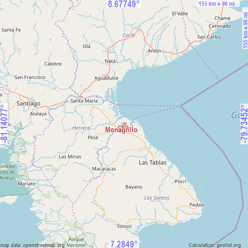
Monagrillo GPS coordinates[2]
7° 58' 54.444" North, 80° 26' 15.504" West
| Map corner | latitude | longitude |
|---|---|---|
| Upper-left | 8.67749°, | -81.14077° |
| Center: | 7.98179°, | -80.43764° |
| Lower-right: | 7.2849°, | -79.73452° |
| Map W x H: | 154.8×154.8 km | = 96.2×96.2mi |
| max Lat: | 9.60898° ⇑82.2% North |
| Monagrillo: | 7.98179° |
| min Lat: | ⇓17.8% South 7.26534° |
| min Long | Monagrillo | max Long |
| -82.91275° | -80.43764° | -77.38965° |
| W 55.7%⇐ | ⇒44.3% E |
Elevation
Elevation of Monagrillo is 29 m = 95 ft, and this is 143.1 m = 469 ft below average elevation for this country.
| Max E: |
2103 m = 6900 ft | 75.7% |
| Avg. | 172.1 m = 565 ft | |
| Monagrillo | 29 m = 95 ft | |
Min E: |
-1 m = -3 ft | 24.3% |
See also: Panama elevation on elevation.city.
Geographical zone
Monagrillo is located in North Torrid zone (between Equator and Tropic of Cancer). Distance of Equator is 887.5 km =551.5 mi to South.| Distance of | km | miles | from Monagrillo |
|---|---|---|---|
| North Pole | 9119.6 | 5666.7 | to North |
| Arctic Circle | 6513.7 | 4047.4 | to North |
| Tropic Cancer | 1718.4 | 1067.8 | to North |
| Equator | 887.5 | 551.5 | to South |


Nearby cities:
15 places around Monagrillo: (largest is in red/bold)
• Boca de Parita
3.4 km =2.1 mi,  329°
329°
• Chitré
2.5 km =1.6 mi,  158°
158°
• El Barrero
9.9 km =6.2 mi,  237°
237°
• El Ejido
9.2 km =5.7 mi,  142°
142°
• La Arena
3.4 km =2.1 mi, 242°
• La Espigadilla
12.1 km =7.5 mi,  154°
154°
• Llano Bonito
2.4 km =1.5 mi,  104°
104°
• Llano Largo
8.5 km =5.3 mi,  171°
171°
• Los Hatillos
12.5 km =7.8 mi, 242°
• Los Olivos
9.2 km =5.7 mi,  217°
217°
• Los Santos
5.9 km =3.7 mi, 156°
• Los Ángeles
14 km =8.7 mi, 140°
• Parita
9.3 km =5.8 mi,  278°
278°
• San Juan Bautista
3.6 km =2.2 mi,  130°
130°
• Santa Ana Arriba
9.8 km =6.1 mi,  123°
123°
Sources, notices
• [Note1] Compared only with cities in Panama existing in our database
• [Src1] Map data: © OpenStreetMap contributors (CC-BY-SA)
• [Src2] Other city data from geonames.org with taken over terms of usage.
• [Src3] Geographical zone / Annual Mean Temperature by Robert A. Rohde @ Wikipedia
