Parita geodata
Parita (Herrera) is a seat of a second-order administrative division; located in Panama in America/Panama (GMT-5) time zone. With population of 2,864 people, there are 96 cities with bigger population in this country. Compared to other cities in Panama, 81.6% of cities are located further ↑North; 52.5% of cities are located further ←West and 73.6% of cities have higher elevation than Parita. Note1


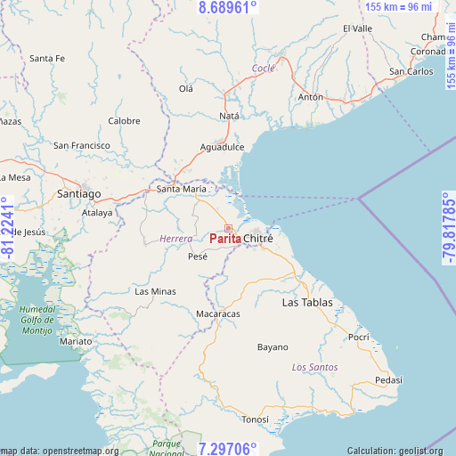
Parita GPS coordinates[2]
7° 59' 38.148" North, 80° 31' 15.492" West
| Map corner | latitude | longitude |
|---|---|---|
| Upper-left | 8.68961°, | -81.2241° |
| Center: | 7.99393°, | -80.52097° |
| Lower-right: | 7.29706°, | -79.81785° |
| Map W x H: | 154.8×154.8 km | = 96.2×96.2mi |
| max Lat: | 9.60898° ⇑81.6% North |
| Parita: | 7.99393° |
| min Lat: | ⇓18.4% South 7.26534° |
| min Long | Parita | max Long |
| -82.91275° | -80.52097° | -77.38965° |
| W 52.5%⇐ | ⇒47.5% E |
Elevation
Elevation of Parita is 32 m = 105 ft, and this is 140.1 m = 460 ft below average elevation for this country.
| Max E: |
2103 m = 6900 ft | 73.6% |
| Avg. | 172.1 m = 565 ft | |
| Parita | 32 m = 105 ft | |
Min E: |
-1 m = -3 ft | 26.4% |
See also: Panama elevation on elevation.city.
Geographical zone
Parita is located in North Torrid zone (between Equator and Tropic of Cancer). Distance of Equator is 888.8 km =552.3 mi to South.| Distance of | km | miles | from Parita |
|---|---|---|---|
| North Pole | 9118.2 | 5665.8 | to North |
| Arctic Circle | 6512.3 | 4046.6 | to North |
| Tropic Cancer | 1717.1 | 1067 | to North |
| Equator | 888.8 | 552.3 | to South |


Nearby cities:
15 places around Parita: (largest is in red/bold)
• Boca de Parita
7.6 km =4.7 mi,  78°
78°
• Cabuya
12.9 km =8 mi,  288°
288°
• Chitré
10.7 km =6.6 mi,  110°
110°
• El Barrero
6.8 km =4.2 mi,  173°
173°
• El Pájaro
7.8 km =4.8 mi,  223°
223°
• La Arena
6.8 km =4.2 mi,  115°
115°
• Llano Bonito
11.7 km =7.3 mi,  99°
99°
• Los Castillos
10.8 km =6.7 mi,  265°
265°
• Los Hatillos
7.3 km =4.5 mi,  195°
195°
• Los Olivos
9.4 km =5.8 mi,  157°
157°
• Los Santos
13.3 km =8.3 mi, 120°
• Monagrillo
9.3 km =5.8 mi, 98°
• París
7.3 km =4.5 mi,  329°
329°
• Portobelillo
8.6 km =5.3 mi, 287°
• San Juan Bautista
12.5 km =7.8 mi, 107°
Sources, notices
• [Note1] Compared only with cities in Panama existing in our database
• [Src1] Map data: © OpenStreetMap contributors (CC-BY-SA)
• [Src2] Other city data from geonames.org with taken over terms of usage.
• [Src3] Geographical zone / Annual Mean Temperature by Robert A. Rohde @ Wikipedia
