La Arena geodata
La Arena (Herrera) is a seat of a third-order administrative division; located in Panama in America/Panama (GMT-5) time zone. With population of 7,175 people, there are 54 cities with bigger population in this country. Compared to other cities in Panama, 83.2% of cities are located further ↑North; 54.2% of cities are located further ←West and 66.5% of cities have higher elevation than La Arena. Note1


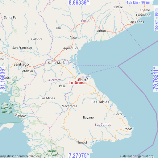
La Arena GPS coordinates[2]
7° 58' 3.576" North, 80° 27' 54.828" West
| Map corner | latitude | longitude |
|---|---|---|
| Upper-left | 8.66339°, | -81.16836° |
| Center: | 7.96766°, | -80.46523° |
| Lower-right: | 7.27075°, | -79.76211° |
| Map W x H: | 154.8×154.9 km | = 96.2×96.3mi |
| max Lat: | 9.60898° ⇑83.2% North |
| La Arena: | 7.96766° |
| min Lat: | ⇓16.8% South 7.26534° |
| min Long | La Arena | max Long |
| -82.91275° | -80.46523° | -77.38965° |
| W 54.2%⇐ | ⇒45.8% E |
Elevation
Elevation of La Arena is 40 m = 131 ft, and this is 132.1 m = 433 ft below average elevation for this country.
| Max E: |
2103 m = 6900 ft | 66.5% |
| Avg. | 172.1 m = 565 ft | |
| La Arena | 40 m = 131 ft | |
Min E: |
-1 m = -3 ft | 33.5% |
See also: Panama elevation on elevation.city.
Geographical zone
La Arena is located in North Torrid zone (between Equator and Tropic of Cancer). Distance of Equator is 885.9 km =550.5 mi to South.| Distance of | km | miles | from La Arena |
|---|---|---|---|
| North Pole | 9121.1 | 5667.6 | to North |
| Arctic Circle | 6515.3 | 4048.4 | to North |
| Tropic Cancer | 1720 | 1068.8 | to North |
| Equator | 885.9 | 550.5 | to South |


Nearby cities:
15 places around La Arena: (largest is in red/bold)
• Boca de Parita
4.7 km =2.9 mi,  16°
16°
• Chitré
4 km =2.5 mi,  100°
100°
• El Barrero
6.5 km =4 mi,  234°
234°
• El Ejido
10.3 km =6.4 mi,  123°
123°
• El Pájaro
11.9 km =7.4 mi,  256°
256°
• La Espigadilla
12.4 km =7.7 mi,  138°
138°
• Llano Bonito
5.5 km =3.4 mi,  79°
79°
• Llano Largo
8.1 km =5 mi,  147°
147°
• Los Hatillos
9 km =5.6 mi,  242°
242°
• Los Olivos
6.3 km =3.9 mi,  204°
204°
• Los Santos
6.6 km =4.1 mi,  125°
125°
• Monagrillo
3.4 km =2.1 mi,  62°
62°
• Parita
6.8 km =4.2 mi,  295°
295°
• San Juan Bautista
5.8 km =3.6 mi, 97°
• Santa Ana Arriba
11.8 km =7.3 mi,  109°
109°
Sources, notices
• [Note1] Compared only with cities in Panama existing in our database
• [Src1] Map data: © OpenStreetMap contributors (CC-BY-SA)
• [Src2] Other city data from geonames.org with taken over terms of usage.
• [Src3] Geographical zone / Annual Mean Temperature by Robert A. Rohde @ Wikipedia
