El Espino geodata
El Espino (Veraguas) is a populated place; located in Panama in America/Panama (GMT-5) time zone. With population of 620 people, there are 399 cities with bigger population in this country. Compared to other cities in Panama, 72.8% of cities are located further ↑North; 60.5% of cities are located further →East and 51.4% of cities have lower elevation than El Espino. Note1


El Espino GPS coordinates[2]
8° 11' 37.608" North, 80° 57' 27.72" West
| Map corner | latitude | longitude |
|---|---|---|
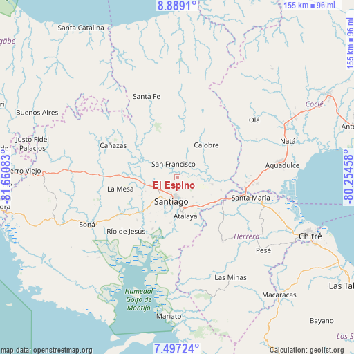
| Upper-left | 8.8891°, | -81.66083° |
| Center: | 8.19378°, | -80.9577° |
| Lower-right: | 7.49724°, | -80.25458° |
| Map W x H: | 154.8×154.8 km | = 96.2×96.2mi |
| max Lat: | 9.60898° ⇑72.8% North |
| El Espino: | 8.19378° |
| min Lat: | ⇓27.2% South 7.26534° |
| min Long | El Espino | max Long |
| -82.91275° | -80.9577° | -77.38965° |
| W 39.5%⇐ | ⇒60.5% E |
Elevation
Elevation of El Espino is 76 m = 249 ft, and this is 96.1 m = 315 ft below average elevation for this country.
| Max E: |
2103 m = 6900 ft | 48.6% |
| Avg. | 172.1 m = 565 ft | |
| El Espino | 76 m = 249 ft | |
Min E: |
-1 m = -3 ft | 51.4% |
See also: Panama elevation on elevation.city.
Geographical zone
El Espino is located in North Torrid zone (between Equator and Tropic of Cancer). Distance of Equator is 911.1 km =566.1 mi to South.| Distance of | km | miles | from El Espino |
|---|---|---|---|
| North Pole | 9096 | 5652 | to North |
| Arctic Circle | 6490.1 | 4032.8 | to North |
| Tropic Cancer | 1694.9 | 1053.2 | to North |
| Equator | 911.1 | 566.1 | to South |


Nearby cities:
15 places around El Espino: (largest is in red/bold)
• Boquerón
12.2 km =7.6 mi,  62°
62°
• Canto del Llano
7.7 km =4.8 mi,  184°
184°
• El Uvito
9.1 km =5.7 mi,  199°
199°
• La Mata
14.4 km =8.9 mi,  143°
143°
• La Peña
10.6 km =6.6 mi,  226°
226°
• La Soledad
7.4 km =4.6 mi,  209°
209°
• Las Barreras
10.8 km =6.7 mi, 203°
• Los Algarrobos
11.3 km =7 mi, 213°
• Los Higos
10.8 km =6.7 mi,  83°
83°
• Los Remedios
9.5 km =5.9 mi, 230°
• Punta Delgadita
9.5 km =5.9 mi,  171°
171°
• San Antonio
13.7 km =8.5 mi, 168°
• San Francisco
6.2 km =3.9 mi,  342°
342°
• San Juan
13.7 km =8.5 mi,  332°
332°
• Santiago de Veraguas
10.8 km =6.7 mi, 195°
Sources, notices
• [Note1] Compared only with cities in Panama existing in our database
• [Src1] Map data: © OpenStreetMap contributors (CC-BY-SA)
• [Src2] Other city data from geonames.org with taken over terms of usage.
• [Src3] Geographical zone / Annual Mean Temperature by Robert A. Rohde @ Wikipedia
