Punta Delgadita geodata
Punta Delgadita (Veraguas) is a populated place; located in Panama in America/Panama (GMT-5) time zone. With population of 919 people, there are 278 cities with bigger population in this country. Compared to other cities in Panama, 76.4% of cities are located further ↑North; 60.1% of cities are located further →East and 56.4% of cities have lower elevation than Punta Delgadita. Note1


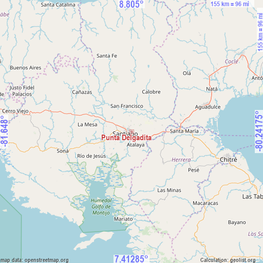
Punta Delgadita GPS coordinates[2]
8° 6' 34.308" North, 80° 56' 41.532" West
| Map corner | latitude | longitude |
|---|---|---|
| Upper-left | 8.805°, | -81.648° |
| Center: | 8.10953°, | -80.94487° |
| Lower-right: | 7.41285°, | -80.24175° |
| Map W x H: | 154.8×154.8 km | = 96.2×96.2mi |
| max Lat: | 9.60898° ⇑76.4% North |
| Punta Delgadita: | 8.10953° |
| min Lat: | ⇓23.6% South 7.26534° |
| min Long | Punta Delgadita | max Long |
| -82.91275° | -80.94487° | -77.38965° |
| W 39.9%⇐ | ⇒60.1% E |
Elevation
Elevation of Punta Delgadita is 92 m = 302 ft, and this is 80.1 m = 263 ft below average elevation for this country.
| Max E: |
2103 m = 6900 ft | 43.6% |
| Avg. | 172.1 m = 565 ft | |
| Punta Delgadita | 92 m = 302 ft | |
Min E: |
-1 m = -3 ft | 56.4% |
See also: Panama elevation on elevation.city.
Geographical zone
Punta Delgadita is located in North Torrid zone (between Equator and Tropic of Cancer). Distance of Equator is 901.7 km =560.3 mi to South.| Distance of | km | miles | from Punta Delgadita |
|---|---|---|---|
| North Pole | 9105.4 | 5657.8 | to North |
| Arctic Circle | 6499.5 | 4038.6 | to North |
| Tropic Cancer | 1704.2 | 1058.9 | to North |
| Equator | 901.7 | 560.3 | to South |


Nearby cities:
15 places around Punta Delgadita: (largest is in red/bold)
• Atalaya
7.8 km =4.8 mi,  163°
163°
• Canto del Llano
2.7 km =1.7 mi,  309°
309°
• El Espino
9.5 km =5.9 mi,  351°
351°
• El Uvito
4.4 km =2.7 mi,  280°
280°
• La Colorada
11.6 km =7.2 mi,  202°
202°
• La Mata
7.5 km =4.7 mi,  107°
107°
• La Montañuela
13 km =8.1 mi,  136°
136°
• La Peña
9.3 km =5.8 mi, 282°
• La Soledad
5.8 km =3.6 mi,  299°
299°
• Las Barreras
5.8 km =3.6 mi,  264°
264°
• Los Algarrobos
7.6 km =4.7 mi,  269°
269°
• Los Boquerones
10.5 km =6.5 mi, 108°
• Los Remedios
9.4 km =5.8 mi,  291°
291°
• San Antonio
4.3 km =2.7 mi, 160°
• Santiago de Veraguas
4.4 km =2.7 mi, 255°
Sources, notices
• [Note1] Compared only with cities in Panama existing in our database
• [Src1] Map data: © OpenStreetMap contributors (CC-BY-SA)
• [Src2] Other city data from geonames.org with taken over terms of usage.
• [Src3] Geographical zone / Annual Mean Temperature by Robert A. Rohde @ Wikipedia
