Los Algarrobos geodata
Los Algarrobos (Veraguas) is a seat of a third-order administrative division; located in Panama in America/Panama (GMT-5) time zone. With population of 1,977 people, there are 120 cities with bigger population in this country. Compared to other cities in Panama, 76.6% of cities are located further ↑North; 61.8% of cities are located further →East and 62.2% of cities have lower elevation than Los Algarrobos. Note1


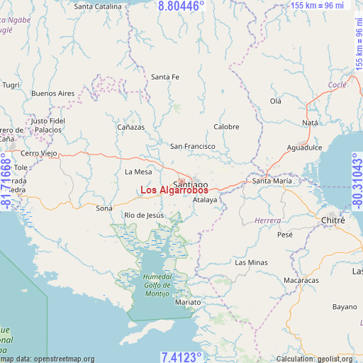
Los Algarrobos GPS coordinates[2]
8° 6' 32.328" North, 81° 0' 48.78" West
| Map corner | latitude | longitude |
|---|---|---|
| Upper-left | 8.80446°, | -81.71668° |
| Center: | 8.10898°, | -81.01355° |
| Lower-right: | 7.4123°, | -80.31043° |
| Map W x H: | 154.8×154.8 km | = 96.2×96.2mi |
| max Lat: | 9.60898° ⇑76.6% North |
| Los Algarrobos: | 8.10898° |
| min Lat: | ⇓23.4% South 7.26534° |
| min Long | Los Algarrobos | max Long |
| -82.91275° | -81.01355° | -77.38965° |
| W 38.2%⇐ | ⇒61.8% E |
Elevation
Elevation of Los Algarrobos is 115 m = 377 ft, and this is 57.1 m = 187 ft below average elevation for this country.
| Max E: |
2103 m = 6900 ft | 37.8% |
| Avg. | 172.1 m = 565 ft | |
| Los Algarrobos | 115 m = 377 ft | |
Min E: |
-1 m = -3 ft | 62.2% |
See also: Panama elevation on elevation.city.
Geographical zone
Los Algarrobos is located in North Torrid zone (between Equator and Tropic of Cancer). Distance of Equator is 901.6 km =560.2 mi to South.| Distance of | km | miles | from Los Algarrobos |
|---|---|---|---|
| North Pole | 9105.4 | 5657.8 | to North |
| Arctic Circle | 6499.5 | 4038.6 | to North |
| Tropic Cancer | 1704.3 | 1059 | to North |
| Equator | 901.6 | 560.2 | to South |


Nearby cities:
15 places around Los Algarrobos: (largest is in red/bold)
• Atalaya
12.2 km =7.6 mi,  127°
127°
• Canto del Llano
5.8 km =3.6 mi,  72°
72°
• El Espino
11.3 km =7 mi,  33°
33°
• El Uvito
3.3 km =2.1 mi,  75°
75°
• La Colorada
11.1 km =6.9 mi,  164°
164°
• La Peña
2.6 km =1.6 mi,  324°
324°
• La Soledad
3.9 km =2.4 mi,  40°
40°
• Las Barreras
1.8 km =1.1 mi,  104°
104°
• Llano Grande
14 km =8.7 mi,  254°
254°
• Los Remedios
3.6 km =2.2 mi,  341°
341°
• Montijo
14.2 km =8.8 mi,  199°
199°
• Punta Delgadita
7.6 km =4.7 mi,  89°
89°
• San Antonio
9.8 km =6.1 mi,  114°
114°
• San Pedro del Espino
8.8 km =5.5 mi,  293°
293°
• Santiago de Veraguas
3.5 km =2.2 mi, 106°
Sources, notices
• [Note1] Compared only with cities in Panama existing in our database
• [Src1] Map data: © OpenStreetMap contributors (CC-BY-SA)
• [Src2] Other city data from geonames.org with taken over terms of usage.
• [Src3] Geographical zone / Annual Mean Temperature by Robert A. Rohde @ Wikipedia
