Las Uvas geodata
Las Uvas (Panamá Oeste) is a seat of a third-order administrative division; located in Panama in America/Panama (GMT-5) time zone. With population of 482 people, there are 495 cities with bigger population in this country. Compared to other cities in Panama, 52% of cities are located further ↑North; 73.2% of cities are located further ←West and 56.3% of cities have higher elevation than Las Uvas. Note1


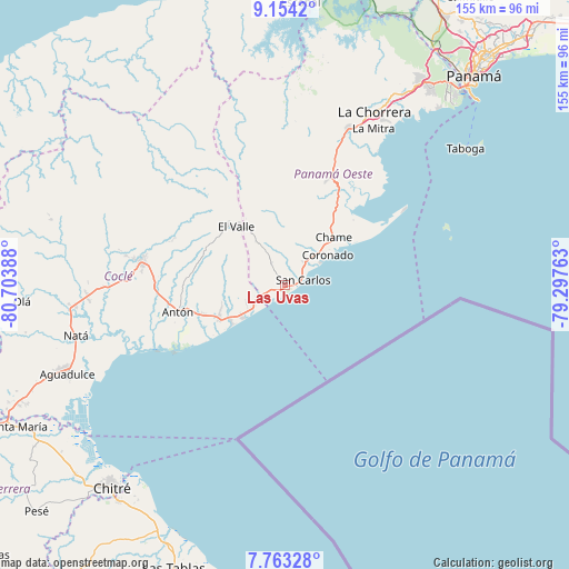
Las Uvas GPS coordinates[2]
8° 27' 33.732" North, 80° 0' 2.7" West
| Map corner | latitude | longitude |
|---|---|---|
| Upper-left | 9.1542°, | -80.70388° |
| Center: | 8.45937°, | -80.00075° |
| Lower-right: | 7.76328°, | -79.29763° |
| Map W x H: | 154.7×154.7 km | = 96.1×96.1mi |
| max Lat: | 9.60898° ⇑52% North |
| Las Uvas: | 8.45937° |
| min Lat: | ⇓48% South 7.26534° |
| min Long | Las Uvas | max Long |
| -82.91275° | -80.00075° | -77.38965° |
| W 73.2%⇐ | ⇒26.8% E |
Elevation
Elevation of Las Uvas is 61 m = 200 ft, and this is 111.1 m = 365 ft below average elevation for this country.
| Max E: |
2103 m = 6900 ft | 56.3% |
| Avg. | 172.1 m = 565 ft | |
| Las Uvas | 61 m = 200 ft | |
Min E: |
-1 m = -3 ft | 43.7% |
See also: Panama elevation on elevation.city.
Geographical zone
Las Uvas is located in North Torrid zone (between Equator and Tropic of Cancer). Distance of Equator is 940.6 km =584.5 mi to South.| Distance of | km | miles | from Las Uvas |
|---|---|---|---|
| North Pole | 9066.5 | 5633.7 | to North |
| Arctic Circle | 6460.6 | 4014.4 | to North |
| Tropic Cancer | 1665.3 | 1034.8 | to North |
| Equator | 940.6 | 584.5 | to South |


Nearby cities:
15 places around Las Uvas: (largest is in red/bold)
• Cabuya
15.2 km =9.4 mi,  32°
32°
• Coloncito
16 km =9.9 mi,  44°
44°
• El Espino
2.4 km =1.5 mi,  326°
326°
• El Higo
4.1 km =2.5 mi,  250°
250°
• El Nance
4.1 km =2.5 mi,  71°
71°
• El Retiro
17 km =10.6 mi,  277°
277°
• Guayabito
10 km =6.2 mi,  351°
351°
• La Ermita
7.4 km =4.6 mi,  267°
267°
• La Laguna
16.9 km =10.5 mi,  342°
342°
• Las Colinas
13.6 km =8.5 mi,  317°
317°
• Las Lajas
12.4 km =7.7 mi, 35°
• Las Matas
10.1 km =6.3 mi, 276°
• San Carlos
4.6 km =2.9 mi, 70°
• San José
11.2 km =7 mi, 43°
• Santa Clara
14.7 km =9.1 mi,  234°
234°
Sources, notices
• [Note1] Compared only with cities in Panama existing in our database
• [Src1] Map data: © OpenStreetMap contributors (CC-BY-SA)
• [Src2] Other city data from geonames.org with taken over terms of usage.
• [Src3] Geographical zone / Annual Mean Temperature by Robert A. Rohde @ Wikipedia
