Las Colinas geodata
Las Colinas (Panamá Oeste) is a populated place; located in Panama in America/Panama (GMT-5) time zone. With population of 1,447 people, there are 162 cities with bigger population in this country. Compared to other cities in Panama, 59.4% of cities are located further ↓South; 71.3% of cities are located further ←West and 86.3% of cities have lower elevation than Las Colinas. Note1


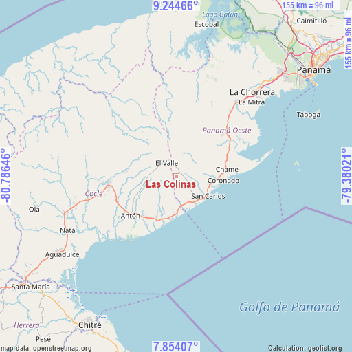
Las Colinas GPS coordinates[2]
8° 33' 0" North, 80° 4' 59.988" West
| Map corner | latitude | longitude |
|---|---|---|
| Upper-left | 9.24466°, | -80.78646° |
| Center: | 8.55°, | -80.08333° |
| Lower-right: | 7.85407°, | -79.38021° |
| Map W x H: | 154.6×154.6 km | = 96.1×96.1mi |
| max Lat: | 9.60898° ⇑40.6% North |
| Las Colinas: | 8.55° |
| min Lat: | ⇓59.4% South 7.26534° |
| min Long | Las Colinas | max Long |
| -82.91275° | -80.08333° | -77.38965° |
| W 71.3%⇐ | ⇒28.7% E |
Elevation
Elevation of Las Colinas is 363 m = 1191 ft, and this is 190.9 m = 626 ft above average elevation for this country.
| Max E: |
2103 m = 6900 ft | 13.7% |
| Las Colinas | 363 m 1191 ft | |
| Avg. | 172.1 m = 565 ft | |
Min E: |
-1 m = -3 ft | 86.3% |
See also: Panama elevation on elevation.city.
Geographical zone
Las Colinas is located in North Torrid zone (between Equator and Tropic of Cancer). Distance of Equator is 950.7 km =590.7 mi to South.| Distance of | km | miles | from Las Colinas |
|---|---|---|---|
| North Pole | 9056.4 | 5627.4 | to North |
| Arctic Circle | 6450.5 | 4008.2 | to North |
| Tropic Cancer | 1655.2 | 1028.5 | to North |
| Equator | 950.7 | 590.7 | to South |


Nearby cities:
15 places around Las Colinas: (largest is in red/bold)
• Alto de La Estancia
11.9 km =7.4 mi,  290°
290°
• Caballero
12.6 km =7.8 mi,  266°
266°
• Cabuya
9.3 km =5.8 mi, 267°
• El Espino
11.2 km =7 mi,  136°
136°
• El Higo
12.5 km =7.8 mi,  155°
155°
• El Retiro
11 km =6.8 mi,  225°
225°
• Guayabito
7.7 km =4.8 mi,  91°
91°
• La Ermita
10.6 km =6.6 mi,  171°
171°
• La Laguna
7.2 km =4.5 mi,  33°
33°
• Las Matas
9 km =5.6 mi,  186°
186°
• Las Uvas
13.6 km =8.5 mi, 137°
• Los Llanitos
5.5 km =3.4 mi,  346°
346°
• Mata Ahogado
7.6 km =4.7 mi, 350°
• Santa Rita
12.7 km =7.9 mi,  239°
239°
• Sorá
12.2 km =7.6 mi,  41°
41°
Sources, notices
• [Note1] Compared only with cities in Panama existing in our database
• [Src1] Map data: © OpenStreetMap contributors (CC-BY-SA)
• [Src2] Other city data from geonames.org with taken over terms of usage.
• [Src3] Geographical zone / Annual Mean Temperature by Robert A. Rohde @ Wikipedia
