El Higo geodata
El Higo (Panamá Oeste) is a seat of a third-order administrative division; located in Panama in America/Panama (GMT-5) time zone. With population of 566 people, there are 430 cities with bigger population in this country. Compared to other cities in Panama, 53.5% of cities are located further ↑North; 72.3% of cities are located further ←West and 52.4% of cities have higher elevation than El Higo. Note1


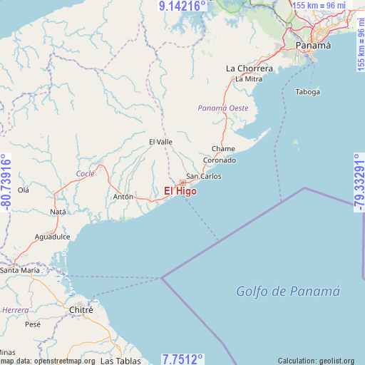
El Higo GPS coordinates[2]
8° 26' 50.316" North, 80° 2' 9.708" West
| Map corner | latitude | longitude |
|---|---|---|
| Upper-left | 9.14216°, | -80.73916° |
| Center: | 8.44731°, | -80.03603° |
| Lower-right: | 7.7512°, | -79.33291° |
| Map W x H: | 154.7×154.7 km | = 96.1×96.1mi |
| max Lat: | 9.60898° ⇑53.5% North |
| El Higo: | 8.44731° |
| min Lat: | ⇓46.5% South 7.26534° |
| min Long | El Higo | max Long |
| -82.91275° | -80.03603° | -77.38965° |
| W 72.3%⇐ | ⇒27.7% E |
Elevation
Elevation of El Higo is 68 m = 223 ft, and this is 104.1 m = 342 ft below average elevation for this country.
| Max E: |
2103 m = 6900 ft | 52.4% |
| Avg. | 172.1 m = 565 ft | |
| El Higo | 68 m = 223 ft | |
Min E: |
-1 m = -3 ft | 47.6% |
See also: Panama elevation on elevation.city.
Geographical zone
El Higo is located in North Torrid zone (between Equator and Tropic of Cancer). Distance of Equator is 939.3 km =583.7 mi to South.| Distance of | km | miles | from El Higo |
|---|---|---|---|
| North Pole | 9067.8 | 5634.5 | to North |
| Arctic Circle | 6461.9 | 4015.2 | to North |
| Tropic Cancer | 1666.7 | 1035.6 | to North |
| Equator | 939.3 | 583.7 | to South |


Nearby cities:
15 places around El Higo: (largest is in red/bold)
• El Espino
4.2 km =2.6 mi,  37°
37°
• El Nance
8.2 km =5.1 mi,  71°
71°
• El Retiro
13.5 km =8.4 mi,  285°
285°
• Farallón
15 km =9.3 mi,  227°
227°
• Guayabito
11.5 km =7.1 mi,  12°
12°
• La Ermita
3.7 km =2.3 mi, 285°
• Las Colinas
12.5 km =7.8 mi,  335°
335°
• Las Lajas
15.9 km =9.9 mi, 44°
• Las Matas
6.6 km =4.1 mi, 291°
• Las Uvas
4.1 km =2.5 mi, 70°
• Los Pollos
14.4 km =8.9 mi,  248°
248°
• Río Hato
16.2 km =10.1 mi,  242°
242°
• San Carlos
8.7 km =5.4 mi, 70°
• San José
14.9 km =9.3 mi,  50°
50°
• Santa Clara
10.8 km =6.7 mi, 228°
Sources, notices
• [Note1] Compared only with cities in Panama existing in our database
• [Src1] Map data: © OpenStreetMap contributors (CC-BY-SA)
• [Src2] Other city data from geonames.org with taken over terms of usage.
• [Src3] Geographical zone / Annual Mean Temperature by Robert A. Rohde @ Wikipedia
