La Ermita geodata
La Ermita (Panamá Oeste) is a seat of a third-order administrative division; located in Panama in America/Panama (GMT-5) time zone. With population of 426 people, there are 510 cities with bigger population in this country. Compared to other cities in Panama, 52.5% of cities are located further ↑North; 71.8% of cities are located further ←West and 58.9% of cities have lower elevation than La Ermita. Note1


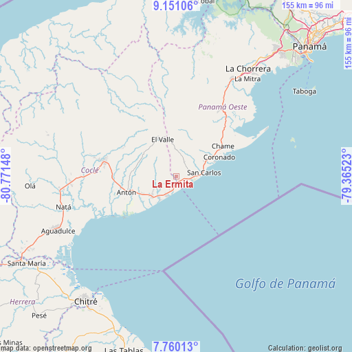
La Ermita GPS coordinates[2]
8° 27' 22.392" North, 80° 4' 6.06" West
| Map corner | latitude | longitude |
|---|---|---|
| Upper-left | 9.15106°, | -80.77148° |
| Center: | 8.45622°, | -80.06835° |
| Lower-right: | 7.76013°, | -79.36523° |
| Map W x H: | 154.7×154.7 km | = 96.1×96.1mi |
| max Lat: | 9.60898° ⇑52.5% North |
| La Ermita: | 8.45622° |
| min Lat: | ⇓47.5% South 7.26534° |
| min Long | La Ermita | max Long |
| -82.91275° | -80.06835° | -77.38965° |
| W 71.8%⇐ | ⇒28.2% E |
Elevation
Elevation of La Ermita is 99 m = 325 ft, and this is 73.1 m = 240 ft below average elevation for this country.
| Max E: |
2103 m = 6900 ft | 41.1% |
| Avg. | 172.1 m = 565 ft | |
| La Ermita | 99 m = 325 ft | |
Min E: |
-1 m = -3 ft | 58.9% |
See also: Panama elevation on elevation.city.
Geographical zone
La Ermita is located in North Torrid zone (between Equator and Tropic of Cancer). Distance of Equator is 940.2 km =584.2 mi to South.| Distance of | km | miles | from La Ermita |
|---|---|---|---|
| North Pole | 9066.8 | 5633.8 | to North |
| Arctic Circle | 6460.9 | 4014.6 | to North |
| Tropic Cancer | 1665.7 | 1035 | to North |
| Equator | 940.2 | 584.2 | to South |


Nearby cities:
15 places around La Ermita: (largest is in red/bold)
• El Chirú
14.6 km =9.1 mi,  243°
243°
• El Espino
6.6 km =4.1 mi,  68°
68°
• El Higo
3.7 km =2.3 mi,  105°
105°
• El Nance
11.4 km =7.1 mi,  81°
81°
• El Retiro
9.8 km =6.1 mi,  285°
285°
• Farallón
13.4 km =8.3 mi,  214°
214°
• Guayabito
11.9 km =7.4 mi,  30°
30°
• Las Colinas
10.6 km =6.6 mi,  351°
351°
• Las Matas
3 km =1.9 mi,  298°
298°
• Las Uvas
7.4 km =4.6 mi,  87°
87°
• Los Pollos
11.7 km =7.3 mi, 236°
• Río Hato
13.7 km =8.5 mi,  231°
231°
• San Carlos
12 km =7.5 mi, 80°
• Santa Clara
9.3 km =5.8 mi, 209°
• Santa Rita
13.3 km =8.3 mi, 288°
Sources, notices
• [Note1] Compared only with cities in Panama existing in our database
• [Src1] Map data: © OpenStreetMap contributors (CC-BY-SA)
• [Src2] Other city data from geonames.org with taken over terms of usage.
• [Src3] Geographical zone / Annual Mean Temperature by Robert A. Rohde @ Wikipedia
