La Mata geodata
La Mata (Veraguas) is a populated place; located in Panama in America/Panama (GMT-5) time zone. With population of 959 people, there are 269 cities with bigger population in this country. Compared to other cities in Panama, 77.6% of cities are located further ↑North; 59.1% of cities are located further →East and 58.1% of cities have higher elevation than La Mata. Note1


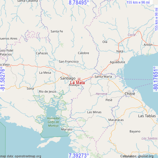
La Mata GPS coordinates[2]
8° 5' 21.984" North, 80° 52' 46.668" West
| Map corner | latitude | longitude |
|---|---|---|
| Upper-left | 8.78495°, | -81.58276° |
| Center: | 8.08944°, | -80.87963° |
| Lower-right: | 7.39273°, | -80.17651° |
| Map W x H: | 154.8×154.8 km | = 96.2×96.2mi |
| max Lat: | 9.60898° ⇑77.6% North |
| La Mata: | 8.08944° |
| min Lat: | ⇓22.4% South 7.26534° |
| min Long | La Mata | max Long |
| -82.91275° | -80.87963° | -77.38965° |
| W 40.9%⇐ | ⇒59.1% E |
Elevation
Elevation of La Mata is 58 m = 190 ft, and this is 114.1 m = 374 ft below average elevation for this country.
| Max E: |
2103 m = 6900 ft | 58.1% |
| Avg. | 172.1 m = 565 ft | |
| La Mata | 58 m = 190 ft | |
Min E: |
-1 m = -3 ft | 41.9% |
See also: Panama elevation on elevation.city.
Geographical zone
La Mata is located in North Torrid zone (between Equator and Tropic of Cancer). Distance of Equator is 899.5 km =558.9 mi to South.| Distance of | km | miles | from La Mata |
|---|---|---|---|
| North Pole | 9107.6 | 5659.2 | to North |
| Arctic Circle | 6501.7 | 4040 | to North |
| Tropic Cancer | 1706.5 | 1060.4 | to North |
| Equator | 899.5 | 558.9 | to South |


Nearby cities:
15 places around La Mata: (largest is in red/bold)
• Atalaya
7.3 km =4.5 mi,  223°
223°
• Canto del Llano
10.1 km =6.3 mi,  292°
292°
• Chupampa
11.4 km =7.1 mi,  97°
97°
• El Espino de Santa Rosa
6.2 km =3.9 mi,  86°
86°
• El Limón
12.3 km =7.6 mi,  106°
106°
• El Pedernal
12.2 km =7.6 mi,  61°
61°
• El Uvito
11.9 km =7.4 mi,  284°
284°
• La Montañuela
7.4 km =4.6 mi,  165°
165°
• La Raya de Santa María
10.5 km =6.5 mi,  37°
37°
• Los Boquerones
3 km =1.9 mi, 112°
• Los Higos
13.1 km =8.1 mi,  9°
9°
• Peñas Chatas
11.8 km =7.3 mi,  134°
134°
• Punta Delgadita
7.5 km =4.7 mi, 287°
• San Antonio
6 km =3.7 mi,  252°
252°
• Santiago de Veraguas
11.5 km =7.1 mi, 275°
Sources, notices
• [Note1] Compared only with cities in Panama existing in our database
• [Src1] Map data: © OpenStreetMap contributors (CC-BY-SA)
• [Src2] Other city data from geonames.org with taken over terms of usage.
• [Src3] Geographical zone / Annual Mean Temperature by Robert A. Rohde @ Wikipedia
