La Montañuela geodata
La Montañuela (Veraguas) is a seat of a third-order administrative division; located in Panama in America/Panama (GMT-5) time zone. With population of 251 people, there are 578 cities with bigger population in this country. Compared to other cities in Panama, 80.4% of cities are located further ↑North; 58.7% of cities are located further →East and 55% of cities have higher elevation than La Montañuela. Note1


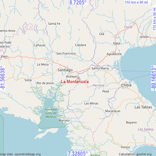
La Montañuela GPS coordinates[2]
8° 1' 29.532" North, 80° 51' 47.7" West
| Map corner | latitude | longitude |
|---|---|---|
| Upper-left | 8.7205°, | -81.56638° |
| Center: | 8.02487°, | -80.86325° |
| Lower-right: | 7.32805°, | -80.16013° |
| Map W x H: | 154.8×154.8 km | = 96.2×96.2mi |
| max Lat: | 9.60898° ⇑80.4% North |
| La Montañuela: | 8.02487° |
| min Lat: | ⇓19.6% South 7.26534° |
| min Long | La Montañuela | max Long |
| -82.91275° | -80.86325° | -77.38965° |
| W 41.3%⇐ | ⇒58.7% E |
Elevation
Elevation of La Montañuela is 63 m = 207 ft, and this is 109.1 m = 358 ft below average elevation for this country.
| Max E: |
2103 m = 6900 ft | 55% |
| Avg. | 172.1 m = 565 ft | |
| La Montañuela | 63 m = 207 ft | |
Min E: |
-1 m = -3 ft | 45% |
See also: Panama elevation on elevation.city.
Geographical zone
La Montañuela is located in North Torrid zone (between Equator and Tropic of Cancer). Distance of Equator is 892.3 km =554.4 mi to South.| Distance of | km | miles | from La Montañuela |
|---|---|---|---|
| North Pole | 9114.8 | 5663.7 | to North |
| Arctic Circle | 6508.9 | 4044.4 | to North |
| Tropic Cancer | 1713.6 | 1064.8 | to North |
| Equator | 892.3 | 554.4 | to South |


Nearby cities:
15 places around La Montañuela: (largest is in red/bold)
• Atalaya
7.1 km =4.4 mi,  285°
285°
• Cabuya
11.9 km =7.4 mi,  113°
113°
• Chupampa
11.1 km =6.9 mi,  59°
59°
• El Barrito
11.8 km =7.3 mi,  232°
232°
• El Espino de Santa Rosa
8.7 km =5.4 mi,  29°
29°
• El Limón
10.6 km =6.6 mi,  69°
69°
• La Carrillo
6.6 km =4.1 mi,  200°
200°
• La Colorada
13.6 km =8.5 mi,  264°
264°
• La Mata
7.4 km =4.6 mi,  345°
345°
• Los Boquerones
6.1 km =3.8 mi,  8°
8°
• Ocú
13.2 km =8.2 mi,  135°
135°
• Peñas Chatas
6.7 km =4.2 mi,  99°
99°
• Punta Delgadita
13 km =8.1 mi,  316°
316°
• San Antonio
9.3 km =5.8 mi,  305°
305°
• San José
8.3 km =5.2 mi,  167°
167°
Sources, notices
• [Note1] Compared only with cities in Panama existing in our database
• [Src1] Map data: © OpenStreetMap contributors (CC-BY-SA)
• [Src2] Other city data from geonames.org with taken over terms of usage.
• [Src3] Geographical zone / Annual Mean Temperature by Robert A. Rohde @ Wikipedia
