Icantí geodata
Icantí (Panamá) is a populated place; located in Panama in America/Panama (GMT-5) time zone. With population of 644 people, there are 387 cities with bigger population in this country. Compared to other cities in Panama, 92.1% of cities are located further ↓South; 92.9% of cities are located further ←West and 57.3% of cities have higher elevation than Icantí. Note1


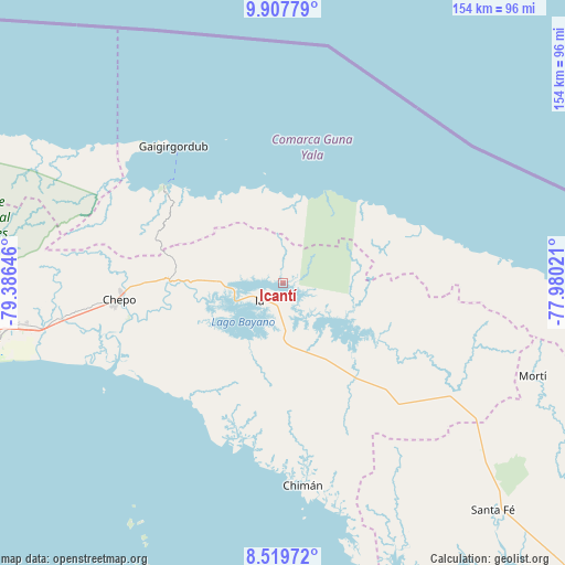
Icantí GPS coordinates[2]
9° 12' 51.984" North, 78° 40' 59.988" West
| Map corner | latitude | longitude |
|---|---|---|
| Upper-left | 9.90779°, | -79.38646° |
| Center: | 9.21444°, | -78.68333° |
| Lower-right: | 8.51972°, | -77.98021° |
| Map W x H: | 154.3×154.3 km | = 95.9×95.9mi |
| max Lat: | 9.60898° ⇑7.9% North |
| Icantí: | 9.21444° |
| min Lat: | ⇓92.1% South 7.26534° |
| min Long | Icantí | max Long |
| -82.91275° | -78.68333° | -77.38965° |
| W 92.9%⇐ | ⇒7.1% E |
Elevation
Elevation of Icantí is 59 m = 194 ft, and this is 113.1 m = 371 ft below average elevation for this country.
| Max E: |
2103 m = 6900 ft | 57.3% |
| Avg. | 172.1 m = 565 ft | |
| Icantí | 59 m = 194 ft | |
Min E: |
-1 m = -3 ft | 42.7% |
See also: Panama elevation on elevation.city.
Geographical zone
Icantí is located in North Torrid zone (between Equator and Tropic of Cancer). Distance of Equator is 1024.5 km =636.6 mi to South.| Distance of | km | miles | from Icantí |
|---|---|---|---|
| North Pole | 8982.5 | 5581.5 | to North |
| Arctic Circle | 6376.6 | 3962.2 | to North |
| Tropic Cancer | 1581.4 | 982.6 | to North |
| Equator | 1024.5 | 636.6 | to South |


Nearby cities:
15 places around Icantí: (largest is in red/bold)
• Cartí Sugdup
41.1 km =25.5 mi,  312°
312°
• Cañita
23.3 km =14.5 mi,  272°
272°
• Chepo
46.1 km =28.6 mi,  263°
263°
• El Porvenir
47.8 km =29.7 mi,  321°
321°
• El Progreso
47.9 km =29.8 mi,  276°
276°
• Ipetí
33.6 km =20.9 mi,  144°
144°
• Isla Tigre
29.9 km =18.6 mi,  36°
36°
• Las Margaritas
44.5 km =27.7 mi, 265°
• Narganá
27.6 km =17.1 mi,  22°
22°
• Playón Chico
50.6 km =31.4 mi,  77°
77°
• Pásiga
39.6 km =24.6 mi,  218°
218°
• Tortí
44.6 km =27.7 mi, 136°
• Tubualá
51 km =31.7 mi, 311°
• Unión Santeña
42.3 km =26.3 mi,  175°
175°
• Unión de Azuero
53.9 km =33.5 mi, 262°
Sources, notices
• [Note1] Compared only with cities in Panama existing in our database
• [Src1] Map data: © OpenStreetMap contributors (CC-BY-SA)
• [Src2] Other city data from geonames.org with taken over terms of usage.
• [Src3] Geographical zone / Annual Mean Temperature by Robert A. Rohde @ Wikipedia
