Narganá geodata
Narganá (Guna Yala) is a populated place; located in Panama in America/Panama (GMT-5) time zone. With population of 1,090 people, there are 226 cities with bigger population in this country. Compared to other cities in Panama, 97.7% of cities are located further ↓South; 93.3% of cities are located further ←West and 98.6% of cities have higher elevation than Narganá. Note1


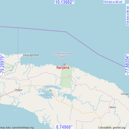
Narganá GPS coordinates[2]
9° 26' 38.184" North, 78° 35' 11.976" West
| Map corner | latitude | longitude |
|---|---|---|
| Upper-left | 10.13682°, | -79.28979° |
| Center: | 9.44394°, | -78.58666° |
| Lower-right: | 8.74966°, | -77.88354° |
| Map W x H: | 154.2×154.2 km | = 95.8×95.8mi |
| max Lat: | 9.60898° ⇑2.3% North |
| Narganá: | 9.44394° |
| min Lat: | ⇓97.7% South 7.26534° |
| min Long | Narganá | max Long |
| -82.91275° | -78.58666° | -77.38965° |
| W 93.3%⇐ | ⇒6.7% E |
Elevation
Elevation of Narganá is 4 m = 13 ft, and this is 168.1 m = 552 ft below average elevation for this country.
| Max E: |
2103 m = 6900 ft | 98.6% |
| Avg. | 172.1 m = 565 ft | |
| Narganá | 4 m = 13 ft | |
Min E: |
-1 m = -3 ft | 1.4% |
See also: Panama elevation on elevation.city.
Geographical zone
Narganá is located in North Torrid zone (between Equator and Tropic of Cancer). Distance of Equator is 1050.1 km =652.5 mi to South.| Distance of | km | miles | from Narganá |
|---|---|---|---|
| North Pole | 8957 | 5565.6 | to North |
| Arctic Circle | 6351.1 | 3946.4 | to North |
| Tropic Cancer | 1555.9 | 966.8 | to North |
| Equator | 1050.1 | 652.5 | to South |


Nearby cities:
15 places around Narganá: (largest is in red/bold)
• Ailigandí
65.8 km =40.9 mi,  111°
111°
• Cartí Sugdup
40.9 km =25.4 mi,  273°
273°
• Cañita
41.9 km =26 mi,  233°
233°
• Chepo
64.1 km =39.8 mi,  241°
241°
• El Porvenir
41.9 km =26 mi,  286°
286°
• El Progreso
61.4 km =38.2 mi,  251°
251°
• Icantí
27.6 km =17.1 mi,  202°
202°
• Ipetí
53.6 km =33.3 mi,  170°
170°
• Isla Tigre
7.4 km =4.6 mi,  102°
102°
• Las Margaritas
62.1 km =38.6 mi, 242°
• Playón Chico
41.5 km =25.8 mi, 110°
• Pásiga
66.6 km =41.4 mi,  212°
212°
• San Ignacio de Tupile
50.7 km =31.5 mi, 109°
• Tortí
61.4 km =38.2 mi,  161°
161°
• Tubualá
49.6 km =30.8 mi,  279°
279°
Sources, notices
• [Note1] Compared only with cities in Panama existing in our database
• [Src1] Map data: © OpenStreetMap contributors (CC-BY-SA)
• [Src2] Other city data from geonames.org with taken over terms of usage.
• [Src3] Geographical zone / Annual Mean Temperature by Robert A. Rohde @ Wikipedia
