El Bale geodata
El Bale (Veraguas) is a seat of a third-order administrative division; located in Panama in America/Panama (GMT-5) time zone. In our database, there are 694 cities with bigger population. Compared to other cities in Panama, 61.8% of cities are located further ↑North; 67.6% of cities are located further →East and 83% of cities have lower elevation than El Bale. Note1


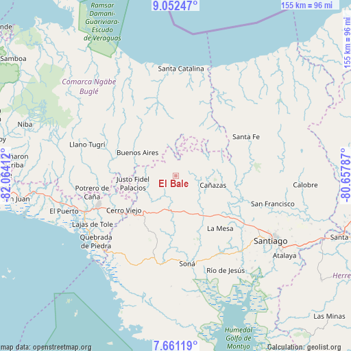
El Bale GPS coordinates[2]
8° 21' 26.82" North, 81° 21' 39.564" West
| Map corner | latitude | longitude |
|---|---|---|
| Upper-left | 9.05247°, | -82.06412° |
| Center: | 8.35745°, | -81.36099° |
| Lower-right: | 7.66119°, | -80.65787° |
| Map W x H: | 154.7×154.7 km | = 96.1×96.1mi |
| max Lat: | 9.60898° ⇑61.8% North |
| El Bale: | 8.35745° |
| min Lat: | ⇓38.2% South 7.26534° |
| min Long | El Bale | max Long |
| -82.91275° | -81.36099° | -77.38965° |
| W 32.4%⇐ | ⇒67.6% E |
Elevation
Elevation of El Bale is 307 m = 1007 ft, and this is 134.9 m = 443 ft above average elevation for this country.
| Max E: |
2103 m = 6900 ft | 17% |
| El Bale | 307 m 1007 ft | |
| Avg. | 172.1 m = 565 ft | |
Min E: |
-1 m = -3 ft | 83% |
See also: Panama elevation on elevation.city.
Geographical zone
El Bale is located in North Torrid zone (between Equator and Tropic of Cancer). Distance of Equator is 929.3 km =577.4 mi to South.| Distance of | km | miles | from El Bale |
|---|---|---|---|
| North Pole | 9077.8 | 5640.7 | to North |
| Arctic Circle | 6471.9 | 4021.5 | to North |
| Tropic Cancer | 1676.7 | 1041.9 | to North |
| Equator | 929.3 | 577.4 | to South |


Nearby cities:
15 places around El Bale: (largest is in red/bold)
• Agua de Salud
19.9 km =12.4 mi,  325°
325°
• Alto de Jesús
17.2 km =10.7 mi,  231°
231°
• Bajo Solis
18.5 km =11.5 mi,  266°
266°
• Buenos Aires
15 km =9.3 mi,  294°
294°
• Cañazas
17 km =10.6 mi,  104°
104°
• Cerro de Plata
7.8 km =4.8 mi,  186°
186°
• El Picador
11.8 km =7.3 mi,  78°
78°
• El Prado
20.7 km =12.9 mi, 229°
• El Rincón
20.8 km =12.9 mi,  202°
202°
• Güibale
17.2 km =10.7 mi,  359°
359°
• Los Valles
20.5 km =12.7 mi,  60°
60°
• Paredón Arriba
21.4 km =13.3 mi, 57°
• San Bartolo
18.8 km =11.7 mi,  150°
150°
• San José
5.1 km =3.2 mi, 289°
• Viguí
15.2 km =9.4 mi,  262°
262°
Sources, notices
• [Note1] Compared only with cities in Panama existing in our database
• [Src1] Map data: © OpenStreetMap contributors (CC-BY-SA)
• [Src2] Other city data from geonames.org with taken over terms of usage.
• [Src3] Geographical zone / Annual Mean Temperature by Robert A. Rohde @ Wikipedia
