Güibale geodata
Güibale (Ngöbe-Buglé) is a seat of a third-order administrative division; located in Panama in America/Panama (GMT-5) time zone. In our database, there are 694 cities with bigger population. Compared to other cities in Panama, 54.2% of cities are located further ↓South; 67.8% of cities are located further →East and 95.6% of cities have lower elevation than Güibale. Note1


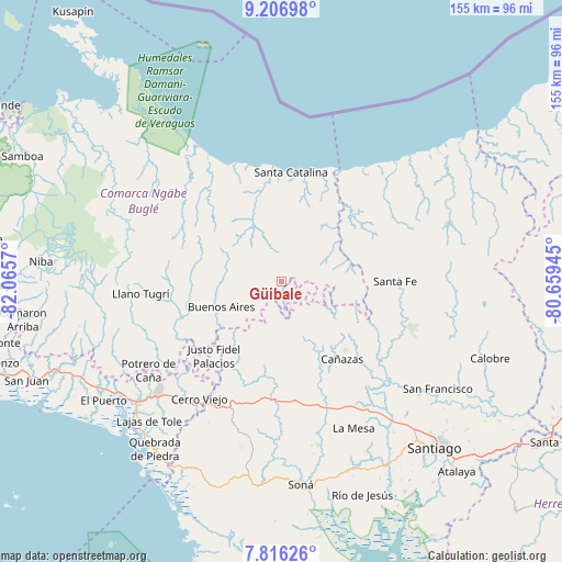
Güibale GPS coordinates[2]
8° 30' 44.1" North, 81° 21' 45.252" West
| Map corner | latitude | longitude |
|---|---|---|
| Upper-left | 9.20698°, | -82.0657° |
| Center: | 8.51225°, | -81.36257° |
| Lower-right: | 7.81626°, | -80.65945° |
| Map W x H: | 154.6×154.6 km | = 96.1×96.1mi |
| max Lat: | 9.60898° ⇑45.8% North |
| Güibale: | 8.51225° |
| min Lat: | ⇓54.2% South 7.26534° |
| min Long | Güibale | max Long |
| -82.91275° | -81.36257° | -77.38965° |
| W 32.2%⇐ | ⇒67.8% E |
Elevation
Elevation of Güibale is 772 m = 2533 ft, and this is 599.9 m = 1968 ft above average elevation for this country.
| Max E: |
2103 m = 6900 ft | 4.4% |
| Güibale | 772 m 2533 ft | |
| Avg. | 172.1 m = 565 ft | |
Min E: |
-1 m = -3 ft | 95.6% |
See also: Panama elevation on elevation.city.
Geographical zone
Güibale is located in North Torrid zone (between Equator and Tropic of Cancer). Distance of Equator is 946.5 km =588.1 mi to South.| Distance of | km | miles | from Güibale |
|---|---|---|---|
| North Pole | 9060.6 | 5630 | to North |
| Arctic Circle | 6454.7 | 4010.8 | to North |
| Tropic Cancer | 1659.4 | 1031.1 | to North |
| Equator | 946.5 | 588.1 | to South |


Nearby cities:
15 places around Güibale: (largest is in red/bold)
• Agua de Salud
11.2 km =7 mi,  265°
265°
• Bajo Solis
25.9 km =16.1 mi,  225°
225°
• Buenos Aires
17.3 km =10.7 mi, 230°
• Cerro Plata
20.5 km =12.7 mi,  259°
259°
• Cerro de Plata
25 km =15.5 mi,  181°
181°
• El Bale
17.2 km =10.7 mi, 179°
• El Picador
19 km =11.8 mi,  141°
141°
• Guayabito
13.5 km =8.4 mi,  282°
282°
• Loma Yuca
23.4 km =14.5 mi,  348°
348°
• Los Valles
19.3 km =12 mi,  111°
111°
• Paredón Arriba
19.2 km =11.9 mi, 107°
• Río Grande
14.4 km =8.9 mi,  34°
34°
• Río Luís
24.9 km =15.5 mi,  40°
40°
• San José
16.2 km =10.1 mi,  196°
196°
• Viguí
24.3 km =15.1 mi,  217°
217°
Sources, notices
• [Note1] Compared only with cities in Panama existing in our database
• [Src1] Map data: © OpenStreetMap contributors (CC-BY-SA)
• [Src2] Other city data from geonames.org with taken over terms of usage.
• [Src3] Geographical zone / Annual Mean Temperature by Robert A. Rohde @ Wikipedia
