El Alto geodata
El Alto (Veraguas) is a seat of a third-order administrative division; located in Panama in America/Panama (GMT-5) time zone. With population of 85 people, there are 667 cities with bigger population in this country. Compared to other cities in Panama, 53.9% of cities are located further ↓South; 62.5% of cities are located further →East and 94.1% of cities have lower elevation than El Alto. Note1


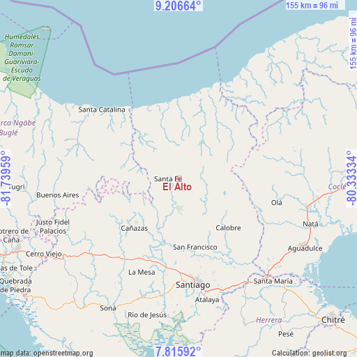
El Alto GPS coordinates[2]
8° 30' 42.876" North, 81° 2' 11.256" West
| Map corner | latitude | longitude |
|---|---|---|
| Upper-left | 9.20664°, | -81.73959° |
| Center: | 8.51191°, | -81.03646° |
| Lower-right: | 7.81592°, | -80.33334° |
| Map W x H: | 154.6×154.6 km | = 96.1×96.1mi |
| max Lat: | 9.60898° ⇑46.1% North |
| El Alto: | 8.51191° |
| min Lat: | ⇓53.9% South 7.26534° |
| min Long | El Alto | max Long |
| -82.91275° | -81.03646° | -77.38965° |
| W 37.5%⇐ | ⇒62.5% E |
Elevation
Elevation of El Alto is 621 m = 2037 ft, and this is 448.9 m = 1473 ft above average elevation for this country.
| Max E: |
2103 m = 6900 ft | 5.9% |
| El Alto | 621 m 2037 ft | |
| Avg. | 172.1 m = 565 ft | |
Min E: |
-1 m = -3 ft | 94.1% |
See also: Panama elevation on elevation.city.
Geographical zone
El Alto is located in North Torrid zone (between Equator and Tropic of Cancer). Distance of Equator is 946.4 km =588.1 mi to South.| Distance of | km | miles | from El Alto |
|---|---|---|---|
| North Pole | 9060.6 | 5630 | to North |
| Arctic Circle | 6454.7 | 4010.8 | to North |
| Tropic Cancer | 1659.5 | 1031.2 | to North |
| Equator | 946.4 | 588.1 | to South |


Nearby cities:
15 places around El Alto: (largest is in red/bold)
• El Coclá
24.7 km =15.3 mi,  148°
148°
• El Pantano
4.6 km =2.9 mi,  308°
308°
• El Peñón
19.2 km =11.9 mi,  159°
159°
• El Picador
28.4 km =17.6 mi,  238°
238°
• Gatú
9.8 km =6.1 mi,  73°
73°
• La Yeguada
21.7 km =13.5 mi,  114°
114°
• Los Corotúes
12.6 km =7.8 mi,  216°
216°
• Los Valles
19.2 km =11.9 mi,  248°
248°
• Monjarás
24.5 km =15.2 mi,  130°
130°
• Paredón Arriba
18.5 km =11.5 mi, 251°
• Piedras Gordas
13.8 km =8.6 mi,  84°
84°
• Río Luís
27.5 km =17.1 mi, 314°
• San José
25.9 km =16.1 mi,  101°
101°
• San Juan
23.3 km =14.5 mi,  174°
174°
• Santa Fé
4.6 km =2.9 mi,  268°
268°
Sources, notices
• [Note1] Compared only with cities in Panama existing in our database
• [Src1] Map data: © OpenStreetMap contributors (CC-BY-SA)
• [Src2] Other city data from geonames.org with taken over terms of usage.
• [Src3] Geographical zone / Annual Mean Temperature by Robert A. Rohde @ Wikipedia
