Piedras Gordas geodata
Piedras Gordas (Veraguas) is a seat of a third-order administrative division; located in Panama in America/Panama (GMT-5) time zone. With population of 94 people, there are 657 cities with bigger population in this country. Compared to other cities in Panama, 55.8% of cities are located further ↓South; 59.4% of cities are located further →East and 93.2% of cities have lower elevation than Piedras Gordas. Note1


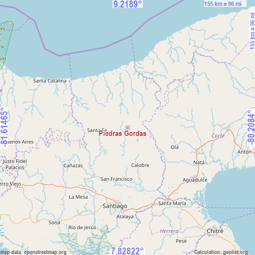
Piedras Gordas GPS coordinates[2]
8° 31' 27.084" North, 80° 54' 41.472" West
| Map corner | latitude | longitude |
|---|---|---|
| Upper-left | 9.2189°, | -81.61465° |
| Center: | 8.52419°, | -80.91152° |
| Lower-right: | 7.82822°, | -80.2084° |
| Map W x H: | 154.6×154.6 km | = 96.1×96.1mi |
| max Lat: | 9.60898° ⇑44.2% North |
| Piedras Gordas: | 8.52419° |
| min Lat: | ⇓55.8% South 7.26534° |
| min Long | Piedras Gordas | max Long |
| -82.91275° | -80.91152° | -77.38965° |
| W 40.6%⇐ | ⇒59.4% E |
Elevation
Elevation of Piedras Gordas is 544 m = 1785 ft, and this is 371.9 m = 1220 ft above average elevation for this country.
| Max E: |
2103 m = 6900 ft | 6.8% |
| Piedras Gordas | 544 m 1785 ft | |
| Avg. | 172.1 m = 565 ft | |
Min E: |
-1 m = -3 ft | 93.2% |
See also: Panama elevation on elevation.city.
Geographical zone
Piedras Gordas is located in North Torrid zone (between Equator and Tropic of Cancer). Distance of Equator is 947.8 km =588.9 mi to South.| Distance of | km | miles | from Piedras Gordas |
|---|---|---|---|
| North Pole | 9059.3 | 5629.2 | to North |
| Arctic Circle | 6453.4 | 4010 | to North |
| Tropic Cancer | 1658.1 | 1030.3 | to North |
| Equator | 947.8 | 588.9 | to South |


Nearby cities:
15 places around Piedras Gordas: (largest is in red/bold)
• Barnizal
19.8 km =12.3 mi,  132°
132°
• Calobre
24.1 km =15 mi,  161°
161°
• El Alto
13.8 km =8.6 mi,  264°
264°
• El Coclá
22.6 km =14 mi,  182°
182°
• El Pantano
17.4 km =10.8 mi,  274°
274°
• El Peñón
20.6 km =12.8 mi,  200°
200°
• El Potrero
20.8 km =12.9 mi,  141°
141°
• Gatú
4.6 km =2.9 mi,  288°
288°
• La Yeguada
12 km =7.5 mi,  150°
150°
• Las Huacas del Quije
18.8 km =11.7 mi,  109°
109°
• Las Sabanas
26.3 km =16.3 mi,  75°
75°
• Los Corotúes
24.1 km =15 mi,  241°
241°
• Monjarás
17.9 km =11.1 mi, 164°
• San José
13.3 km =8.3 mi,  118°
118°
• Santa Fé
18.4 km =11.4 mi, 265°
Sources, notices
• [Note1] Compared only with cities in Panama existing in our database
• [Src1] Map data: © OpenStreetMap contributors (CC-BY-SA)
• [Src2] Other city data from geonames.org with taken over terms of usage.
• [Src3] Geographical zone / Annual Mean Temperature by Robert A. Rohde @ Wikipedia
