Gatú geodata
Gatú (Veraguas) is a seat of a third-order administrative division; located in Panama in America/Panama (GMT-5) time zone. In our database, there are 694 cities with bigger population. Compared to other cities in Panama, 57.6% of cities are located further ↓South; 60.3% of cities are located further →East and 94.8% of cities have lower elevation than Gatú. Note1


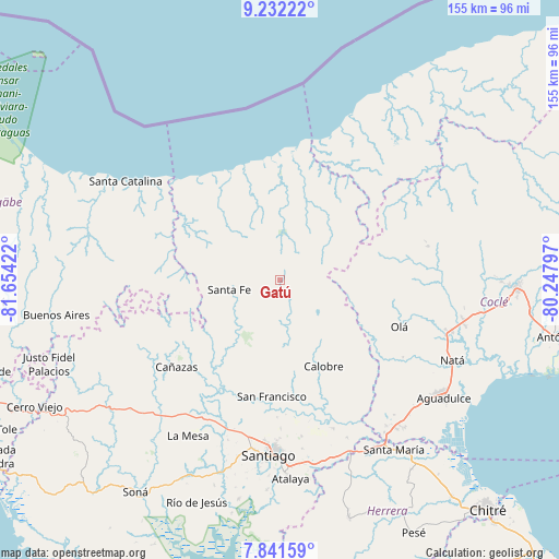
Gatú GPS coordinates[2]
8° 32' 15.144" North, 80° 57' 3.924" West
| Map corner | latitude | longitude |
|---|---|---|
| Upper-left | 9.23222°, | -81.65422° |
| Center: | 8.53754°, | -80.95109° |
| Lower-right: | 7.84159°, | -80.24797° |
| Map W x H: | 154.6×154.6 km | = 96.1×96.1mi |
| max Lat: | 9.60898° ⇑42.4% North |
| Gatú: | 8.53754° |
| min Lat: | ⇓57.6% South 7.26534° |
| min Long | Gatú | max Long |
| -82.91275° | -80.95109° | -77.38965° |
| W 39.7%⇐ | ⇒60.3% E |
Elevation
Elevation of Gatú is 667 m = 2188 ft, and this is 494.9 m = 1624 ft above average elevation for this country.
| Max E: |
2103 m = 6900 ft | 5.2% |
| Gatú | 667 m 2188 ft | |
| Avg. | 172.1 m = 565 ft | |
Min E: |
-1 m = -3 ft | 94.8% |
See also: Panama elevation on elevation.city.
Geographical zone
Gatú is located in North Torrid zone (between Equator and Tropic of Cancer). Distance of Equator is 949.3 km =589.9 mi to South.| Distance of | km | miles | from Gatú |
|---|---|---|---|
| North Pole | 9057.8 | 5628.3 | to North |
| Arctic Circle | 6451.9 | 4009 | to North |
| Tropic Cancer | 1656.6 | 1029.4 | to North |
| Equator | 949.3 | 589.9 | to South |


Nearby cities:
15 places around Gatú: (largest is in red/bold)
• Barnizal
24.1 km =15 mi,  127°
127°
• Calobre
27.2 km =16.9 mi,  153°
153°
• El Alto
9.8 km =6.1 mi,  253°
253°
• El Coclá
24.3 km =15.1 mi,  172°
172°
• El Pantano
13 km =8.1 mi,  270°
270°
• El Peñón
21 km =13 mi,  187°
187°
• El Potrero
24.8 km =15.4 mi,  136°
136°
• La Yeguada
15.7 km =9.8 mi, 139°
• Las Huacas del Quije
23.4 km =14.5 mi,  109°
109°
• Los Corotúes
21.3 km =13.2 mi,  232°
232°
• Monjarás
20.9 km =13 mi, 153°
• Piedras Gordas
4.6 km =2.9 mi, 108°
• San José
17.9 km =11.1 mi,  116°
116°
• San Juan
27 km =16.8 mi,  195°
195°
• Santa Fé
14.3 km =8.9 mi,  257°
257°
Sources, notices
• [Note1] Compared only with cities in Panama existing in our database
• [Src1] Map data: © OpenStreetMap contributors (CC-BY-SA)
• [Src2] Other city data from geonames.org with taken over terms of usage.
• [Src3] Geographical zone / Annual Mean Temperature by Robert A. Rohde @ Wikipedia
