San José geodata
San José (Veraguas) is a seat of a third-order administrative division; located in Panama in America/Panama (GMT-5) time zone. With population of 84 people, there are 669 cities with bigger population in this country. Compared to other cities in Panama, 50.4% of cities are located further ↑North; 56.9% of cities are located further →East and 96.6% of cities have lower elevation than San José. Note1


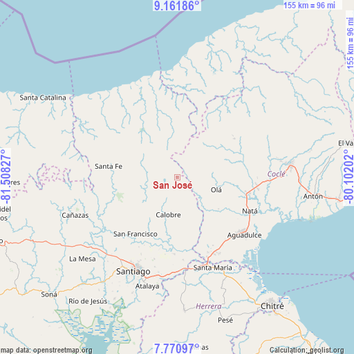
San José GPS coordinates[2]
8° 28' 1.344" North, 80° 48' 18.504" West
| Map corner | latitude | longitude |
|---|---|---|
| Upper-left | 9.16186°, | -81.50827° |
| Center: | 8.46704°, | -80.80514° |
| Lower-right: | 7.77097°, | -80.10202° |
| Map W x H: | 154.7×154.7 km | = 96.1×96.1mi |
| max Lat: | 9.60898° ⇑50.4% North |
| San José: | 8.46704° |
| min Lat: | ⇓49.6% South 7.26534° |
| min Long | San José | max Long |
| -82.91275° | -80.80514° | -77.38965° |
| W 43.1%⇐ | ⇒56.9% E |
Elevation
Elevation of San José is 862 m = 2828 ft, and this is 689.9 m = 2263 ft above average elevation for this country.
| Max E: |
2103 m = 6900 ft | 3.4% |
| San José | 862 m 2828 ft | |
| Avg. | 172.1 m = 565 ft | |
Min E: |
-1 m = -3 ft | 96.6% |
See also: Panama elevation on elevation.city.
Geographical zone
San José is located in North Torrid zone (between Equator and Tropic of Cancer). Distance of Equator is 941.4 km =585 mi to South.| Distance of | km | miles | from San José |
|---|---|---|---|
| North Pole | 9065.6 | 5633.1 | to North |
| Arctic Circle | 6459.7 | 4013.9 | to North |
| Tropic Cancer | 1664.5 | 1034.3 | to North |
| Equator | 941.4 | 585 | to South |


Nearby cities:
15 places around San José: (largest is in red/bold)
• Barnizal
7.6 km =4.7 mi,  156°
156°
• Barranco Colorado
20.6 km =12.8 mi,  114°
114°
• Calobre
16.9 km =10.5 mi,  193°
193°
• El Coclá
20.6 km =12.8 mi,  218°
218°
• El Copé
14.2 km =8.8 mi,  103°
103°
• El Potrero
10.1 km =6.3 mi,  173°
173°
• Gatú
17.9 km =11.1 mi,  296°
296°
• La Laguna
16.5 km =10.3 mi,  149°
149°
• La Yeguada
7 km =4.3 mi,  234°
234°
• Las Huacas del Quije
6 km =3.7 mi,  90°
90°
• Las Sabanas
18.8 km =11.7 mi,  47°
47°
• Monjarás
12.8 km =8 mi,  211°
211°
• Olá
17.8 km =11.1 mi, 107°
• Piedras Gordas
13.3 km =8.3 mi, 298°
• Toza
22.6 km =14 mi,  126°
126°
Sources, notices
• [Note1] Compared only with cities in Panama existing in our database
• [Src1] Map data: © OpenStreetMap contributors (CC-BY-SA)
• [Src2] Other city data from geonames.org with taken over terms of usage.
• [Src3] Geographical zone / Annual Mean Temperature by Robert A. Rohde @ Wikipedia
