Guayabal geodata
Guayabal (Chiriquí) is a populated place; located in Panama in America/Panama (GMT-5) time zone. With population of 582 people, there are 418 cities with bigger population in this country. Compared to other cities in Panama, 51.4% of cities are located further ↑North; 82.9% of cities are located further →East and 52.5% of cities have lower elevation than Guayabal. Note1


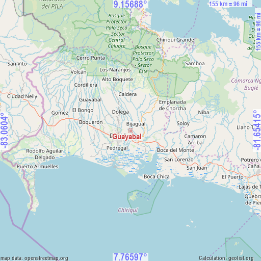
Guayabal GPS coordinates[2]
8° 27' 43.38" North, 82° 21' 26.172" West
| Map corner | latitude | longitude |
|---|---|---|
| Upper-left | 9.15688°, | -83.0604° |
| Center: | 8.46205°, | -82.35727° |
| Lower-right: | 7.76597°, | -81.65415° |
| Map W x H: | 154.7×154.7 km | = 96.1×96.1mi |
| max Lat: | 9.60898° ⇑51.4% North |
| Guayabal: | 8.46205° |
| min Lat: | ⇓48.6% South 7.26534° |
| min Long | Guayabal | max Long |
| -82.91275° | -82.35727° | -77.38965° |
| W 17.1%⇐ | ⇒82.9% E |
Elevation
Elevation of Guayabal is 78 m = 256 ft, and this is 94.1 m = 309 ft below average elevation for this country.
| Max E: |
2103 m = 6900 ft | 47.5% |
| Avg. | 172.1 m = 565 ft | |
| Guayabal | 78 m = 256 ft | |
Min E: |
-1 m = -3 ft | 52.5% |
See also: Panama elevation on elevation.city.
Geographical zone
Guayabal is located in North Torrid zone (between Equator and Tropic of Cancer). Distance of Equator is 940.9 km =584.6 mi to South.| Distance of | km | miles | from Guayabal |
|---|---|---|---|
| North Pole | 9066.2 | 5633.5 | to North |
| Arctic Circle | 6460.3 | 4014.2 | to North |
| Tropic Cancer | 1665 | 1034.6 | to North |
| Equator | 940.9 | 584.6 | to South |


Nearby cities:
15 places around Guayabal: (largest is in red/bold)
• Algarrobos Arriba
9.3 km =5.8 mi,  309°
309°
• Angostura de Cochea Arriba
8.5 km =5.3 mi,  346°
346°
• Bijagual
6.4 km =4 mi,  23°
23°
• Chiriquí
8.7 km =5.4 mi,  151°
151°
• Cochea Abajo
4.8 km =3 mi,  358°
358°
• David
9 km =5.6 mi,  244°
244°
• Dos Ríos Abajo
8.1 km =5 mi,  336°
336°
• Las Lomas
4.9 km =3 mi,  222°
222°
• Los Algarrobos
8.3 km =5.2 mi,  297°
297°
• Mata del Nance
4.9 km =3 mi,  254°
254°
• Nuevo San Carlitos
8.8 km =5.5 mi,  266°
266°
• Portachuelo
6.9 km =4.3 mi,  279°
279°
• Quinteño
4.1 km =2.5 mi, 284°
• Rincón
8.6 km =5.3 mi,  88°
88°
• Rincón Largo
8.5 km =5.3 mi,  320°
320°
Sources, notices
• [Note1] Compared only with cities in Panama existing in our database
• [Src1] Map data: © OpenStreetMap contributors (CC-BY-SA)
• [Src2] Other city data from geonames.org with taken over terms of usage.
• [Src3] Geographical zone / Annual Mean Temperature by Robert A. Rohde @ Wikipedia
