Bijagual geodata
Bijagual (Chiriquí) is a seat of a third-order administrative division; located in Panama in America/Panama (GMT-5) time zone. With population of 257 people, there are 569 cities with bigger population in this country. Compared to other cities in Panama, 54.4% of cities are located further ↓South; 82.7% of cities are located further →East and 64.4% of cities have lower elevation than Bijagual. Note1


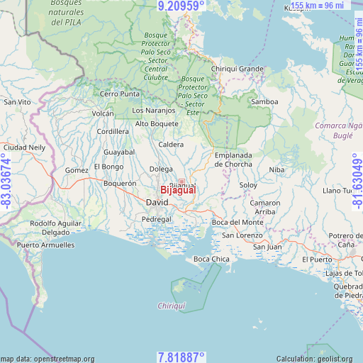
Bijagual GPS coordinates[2]
8° 30' 53.496" North, 82° 20' 0.996" West
| Map corner | latitude | longitude |
|---|---|---|
| Upper-left | 9.20959°, | -83.03674° |
| Center: | 8.51486°, | -82.33361° |
| Lower-right: | 7.81887°, | -81.63049° |
| Map W x H: | 154.6×154.6 km | = 96.1×96.1mi |
| max Lat: | 9.60898° ⇑45.6% North |
| Bijagual: | 8.51486° |
| min Lat: | ⇓54.4% South 7.26534° |
| min Long | Bijagual | max Long |
| -82.91275° | -82.33361° | -77.38965° |
| W 17.3%⇐ | ⇒82.7% E |
Elevation
Elevation of Bijagual is 122 m = 400 ft, and this is 50.1 m = 164 ft below average elevation for this country.
| Max E: |
2103 m = 6900 ft | 35.6% |
| Avg. | 172.1 m = 565 ft | |
| Bijagual | 122 m = 400 ft | |
Min E: |
-1 m = -3 ft | 64.4% |
See also: Panama elevation on elevation.city.
Geographical zone
Bijagual is located in North Torrid zone (between Equator and Tropic of Cancer). Distance of Equator is 946.8 km =588.3 mi to South.| Distance of | km | miles | from Bijagual |
|---|---|---|---|
| North Pole | 9060.3 | 5629.8 | to North |
| Arctic Circle | 6454.4 | 4010.6 | to North |
| Tropic Cancer | 1659.2 | 1031 | to North |
| Equator | 946.8 | 588.3 | to South |


Nearby cities:
15 places around Bijagual: (largest is in red/bold)
• Algarrobos Arriba
9.8 km =6.1 mi,  270°
270°
• Angostura de Cochea Arriba
5.2 km =3.2 mi,  297°
297°
• Caimito
9.8 km =6.1 mi,  287°
287°
• Cochea Abajo
3 km =1.9 mi,  248°
248°
• Dos Ríos Abajo
6 km =3.7 mi,  284°
284°
• Dos Ríos Arriba
8.3 km =5.2 mi, 299°
• Gualaca
4.1 km =2.5 mi,  65°
65°
• Guayabal
6.4 km =4 mi,  203°
203°
• Los Algarrobos
10.2 km =6.3 mi,  258°
258°
• Los Anastacios
10 km =6.2 mi, 279°
• Mata del Nance
10.3 km =6.4 mi,  225°
225°
• Portachuelo
10.5 km =6.5 mi,  243°
243°
• Quinteño
8.2 km =5.1 mi, 233°
• Rincón
8.2 km =5.1 mi,  133°
133°
• Rincón Largo
8 km =5 mi, 274°
Sources, notices
• [Note1] Compared only with cities in Panama existing in our database
• [Src1] Map data: © OpenStreetMap contributors (CC-BY-SA)
• [Src2] Other city data from geonames.org with taken over terms of usage.
• [Src3] Geographical zone / Annual Mean Temperature by Robert A. Rohde @ Wikipedia
