Cerro Cama geodata
Cerro Cama (Panamá Oeste) is a populated place; located in Panama in America/Panama (GMT-5) time zone. With population of 1,274 people, there are 193 cities with bigger population in this country. Compared to other cities in Panama, 84.4% of cities are located further ↓South; 75.6% of cities are located further ←West and 63% of cities have lower elevation than Cerro Cama. Note1


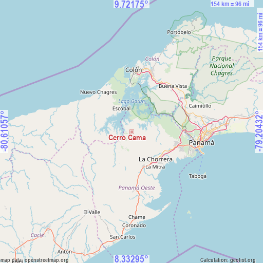
Cerro Cama GPS coordinates[2]
9° 1' 40.872" North, 79° 54' 26.784" West
| Map corner | latitude | longitude |
|---|---|---|
| Upper-left | 9.72175°, | -80.61057° |
| Center: | 9.02802°, | -79.90744° |
| Lower-right: | 8.33295°, | -79.20432° |
| Map W x H: | 154.4×154.4 km | = 95.9×95.9mi |
| max Lat: | 9.60898° ⇑15.6% North |
| Cerro Cama: | 9.02802° |
| min Lat: | ⇓84.4% South 7.26534° |
| min Long | Cerro Cama | max Long |
| -82.91275° | -79.90744° | -77.38965° |
| W 75.6%⇐ | ⇒24.4% E |
Elevation
Elevation of Cerro Cama is 119 m = 390 ft, and this is 53.1 m = 174 ft below average elevation for this country.
| Max E: |
2103 m = 6900 ft | 37% |
| Avg. | 172.1 m = 565 ft | |
| Cerro Cama | 119 m = 390 ft | |
Min E: |
-1 m = -3 ft | 63% |
See also: Panama elevation on elevation.city.
Geographical zone
Cerro Cama is located in North Torrid zone (between Equator and Tropic of Cancer). Distance of Equator is 1003.8 km =623.7 mi to South.| Distance of | km | miles | from Cerro Cama |
|---|---|---|---|
| North Pole | 9003.2 | 5594.3 | to North |
| Arctic Circle | 6397.4 | 3975.2 | to North |
| Tropic Cancer | 1602.1 | 995.5 | to North |
| Equator | 1003.8 | 623.7 | to South |


Nearby cities:
15 places around Cerro Cama: (largest is in red/bold)
• Arenosa
5 km =3.1 mi,  285°
285°
• Arosemena
9.1 km =5.7 mi,  225°
225°
• Cuipo
16.2 km =10.1 mi, 286°
• Escobal
14.3 km =8.9 mi,  334°
334°
• La Colorada
5.5 km =3.4 mi,  193°
193°
• La Laguna
7.4 km =4.6 mi,  76°
76°
• Lagarterita
5.8 km =3.6 mi,  352°
352°
• Mendoza
6.4 km =4 mi,  103°
103°
• Nueva Arenosa
20.1 km =12.5 mi,  208°
208°
• Nuevo Emperador
19.5 km =12.1 mi, 98°
• Potrero Grande
18.6 km =11.6 mi,  151°
151°
• Río Congo
17.5 km =10.9 mi,  112°
112°
• Santa Clara
16.8 km =10.4 mi,  89°
89°
• Santa Rita
19.3 km =12 mi,  170°
170°
• Zangüengas
9 km =5.6 mi, 153°
Sources, notices
• [Note1] Compared only with cities in Panama existing in our database
• [Src1] Map data: © OpenStreetMap contributors (CC-BY-SA)
• [Src2] Other city data from geonames.org with taken over terms of usage.
• [Src3] Geographical zone / Annual Mean Temperature by Robert A. Rohde @ Wikipedia
