La Colorada geodata
La Colorada (Panamá Oeste) is a populated place; located in Panama in America/Panama (GMT-5) time zone. With population of 742 people, there are 340 cities with bigger population in this country. Compared to other cities in Panama, 83.2% of cities are located further ↓South; 74.8% of cities are located further ←West and 66.5% of cities have lower elevation than La Colorada. Note1


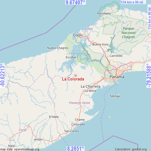
La Colorada GPS coordinates[2]
8° 58' 48.9" North, 79° 55' 8.4" West
| Map corner | latitude | longitude |
|---|---|---|
| Upper-left | 9.67407°, | -80.62213° |
| Center: | 8.98025°, | -79.919° |
| Lower-right: | 8.2851°, | -79.21588° |
| Map W x H: | 154.4×154.4 km | = 95.9×95.9mi |
| max Lat: | 9.60898° ⇑16.8% North |
| La Colorada: | 8.98025° |
| min Lat: | ⇓83.2% South 7.26534° |
| min Long | La Colorada | max Long |
| -82.91275° | -79.919° | -77.38965° |
| W 74.8%⇐ | ⇒25.2% E |
Elevation
Elevation of La Colorada is 130 m = 427 ft, and this is 42.1 m = 138 ft below average elevation for this country.
| Max E: |
2103 m = 6900 ft | 33.5% |
| Avg. | 172.1 m = 565 ft | |
| La Colorada | 130 m = 427 ft | |
Min E: |
-1 m = -3 ft | 66.5% |
See also: Panama elevation on elevation.city.
Geographical zone
La Colorada is located in North Torrid zone (between Equator and Tropic of Cancer). Distance of Equator is 998.5 km =620.4 mi to South.| Distance of | km | miles | from La Colorada |
|---|---|---|---|
| North Pole | 9008.6 | 5597.7 | to North |
| Arctic Circle | 6402.7 | 3978.5 | to North |
| Tropic Cancer | 1607.4 | 998.8 | to North |
| Equator | 998.5 | 620.4 | to South |


Nearby cities:
15 places around La Colorada: (largest is in red/bold)
• Alto del Espino
17.3 km =10.7 mi,  152°
152°
• Arenosa
7.5 km =4.7 mi,  331°
331°
• Arosemena
5.3 km =3.3 mi,  258°
258°
• Cerro Cama
5.5 km =3.4 mi,  13°
13°
• Cuipo
17.3 km =10.7 mi,  304°
304°
• El Coco
17.6 km =10.9 mi,  134°
134°
• La Laguna
11 km =6.8 mi,  49°
49°
• Lagarterita
11 km =6.8 mi,  2°
2°
• Las Ollas Abajo
15.4 km =9.6 mi,  176°
176°
• Mendoza
8.4 km =5.2 mi,  62°
62°
• Nueva Arenosa
14.9 km =9.3 mi,  214°
214°
• Potrero Grande
14.9 km =9.3 mi,  137°
137°
• Río Congo
17.4 km =10.8 mi,  94°
94°
• Santa Rita
14.4 km =8.9 mi,  162°
162°
• Zangüengas
6 km =3.7 mi,  116°
116°
Sources, notices
• [Note1] Compared only with cities in Panama existing in our database
• [Src1] Map data: © OpenStreetMap contributors (CC-BY-SA)
• [Src2] Other city data from geonames.org with taken over terms of usage.
• [Src3] Geographical zone / Annual Mean Temperature by Robert A. Rohde @ Wikipedia
