La Laguna geodata
La Laguna (Panamá Oeste) is a seat of a third-order administrative division; located in Panama in America/Panama (GMT-5) time zone. With population of 312 people, there are 554 cities with bigger population in this country. Compared to other cities in Panama, 85% of cities are located further ↓South; 78.6% of cities are located further ←West and 74.3% of cities have higher elevation than La Laguna. Note1


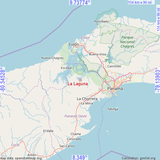
La Laguna GPS coordinates[2]
9° 2' 38.544" North, 79° 50' 31.74" West
| Map corner | latitude | longitude |
|---|---|---|
| Upper-left | 9.73774°, | -80.54528° |
| Center: | 9.04404°, | -79.84215° |
| Lower-right: | 8.349°, | -79.13903° |
| Map W x H: | 154.4×154.4 km | = 95.9×95.9mi |
| max Lat: | 9.60898° ⇑15% North |
| La Laguna: | 9.04404° |
| min Lat: | ⇓85% South 7.26534° |
| min Long | La Laguna | max Long |
| -82.91275° | -79.84215° | -77.38965° |
| W 78.6%⇐ | ⇒21.4% E |
Elevation
Elevation of La Laguna is 30 m = 98 ft, and this is 142.1 m = 466 ft below average elevation for this country.
| Max E: |
2103 m = 6900 ft | 74.3% |
| Avg. | 172.1 m = 565 ft | |
| La Laguna | 30 m = 98 ft | |
Min E: |
-1 m = -3 ft | 25.7% |
See also: Panama elevation on elevation.city.
Geographical zone
La Laguna is located in North Torrid zone (between Equator and Tropic of Cancer). Distance of Equator is 1005.6 km =624.9 mi to South.| Distance of | km | miles | from La Laguna |
|---|---|---|---|
| North Pole | 9001.5 | 5593.3 | to North |
| Arctic Circle | 6395.6 | 3974 | to North |
| Tropic Cancer | 1600.3 | 994.4 | to North |
| Equator | 1005.6 | 624.9 | to South |


Nearby cities:
15 places around La Laguna: (largest is in red/bold)
• Arenosa
12 km =7.5 mi,  267°
267°
• Arosemena
15.9 km =9.9 mi,  239°
239°
• Cerro Cama
7.4 km =4.6 mi,  256°
256°
• Escobal
17.4 km =10.8 mi,  309°
309°
• Hato Montaña
17.9 km =11.1 mi,  140°
140°
• La Colorada
11 km =6.8 mi,  229°
229°
• Lagarterita
8.8 km =5.5 mi,  296°
296°
• Mendoza
3.4 km =2.1 mi,  196°
196°
• Nuevo Emperador
13 km =8.1 mi,  110°
110°
• Potrero Grande
18.2 km =11.3 mi,  175°
175°
• Río Congo
12.4 km =7.7 mi,  134°
134°
• Río Potrero
18 km =11.2 mi,  120°
120°
• San José
17.2 km =10.7 mi, 135°
• Santa Clara
9.8 km =6.1 mi,  100°
100°
• Zangüengas
10.3 km =6.4 mi, 197°
Sources, notices
• [Note1] Compared only with cities in Panama existing in our database
• [Src1] Map data: © OpenStreetMap contributors (CC-BY-SA)
• [Src2] Other city data from geonames.org with taken over terms of usage.
• [Src3] Geographical zone / Annual Mean Temperature by Robert A. Rohde @ Wikipedia
