Arosemena geodata
Arosemena (Panamá Oeste) is a seat of a third-order administrative division; located in Panama in America/Panama (GMT-5) time zone. With population of 127 people, there are 640 cities with bigger population in this country. Compared to other cities in Panama, 82.7% of cities are located further ↓South; 73.4% of cities are located further ←West and 51.9% of cities have lower elevation than Arosemena. Note1


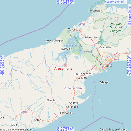
Arosemena GPS coordinates[2]
8° 58' 15.276" North, 79° 57' 59.076" West
| Map corner | latitude | longitude |
|---|---|---|
| Upper-left | 9.66475°, | -80.66954° |
| Center: | 8.97091°, | -79.96641° |
| Lower-right: | 8.27574°, | -79.26329° |
| Map W x H: | 154.4×154.4 km | = 95.9×95.9mi |
| max Lat: | 9.60898° ⇑17.3% North |
| Arosemena: | 8.97091° |
| min Lat: | ⇓82.7% South 7.26534° |
| min Long | Arosemena | max Long |
| -82.91275° | -79.96641° | -77.38965° |
| W 73.4%⇐ | ⇒26.6% E |
Elevation
Elevation of Arosemena is 77 m = 253 ft, and this is 95.1 m = 312 ft below average elevation for this country.
| Max E: |
2103 m = 6900 ft | 48.1% |
| Avg. | 172.1 m = 565 ft | |
| Arosemena | 77 m = 253 ft | |
Min E: |
-1 m = -3 ft | 51.9% |
See also: Panama elevation on elevation.city.
Geographical zone
Arosemena is located in North Torrid zone (between Equator and Tropic of Cancer). Distance of Equator is 997.5 km =619.8 mi to South.| Distance of | km | miles | from Arosemena |
|---|---|---|---|
| North Pole | 9009.6 | 5598.3 | to North |
| Arctic Circle | 6403.7 | 3979.1 | to North |
| Tropic Cancer | 1608.4 | 999.4 | to North |
| Equator | 997.5 | 619.8 | to South |


Nearby cities:
15 places around Arosemena: (largest is in red/bold)
• Arenosa
7.8 km =4.8 mi,  12°
12°
• Caimito
17.9 km =11.1 mi,  173°
173°
• Cerro Cama
9.1 km =5.7 mi,  45°
45°
• Cirí de Los Sotos
13.8 km =8.6 mi,  270°
270°
• Cuipo
14.2 km =8.8 mi,  320°
320°
• El Guabo
17.5 km =10.9 mi,  312°
312°
• La Colorada
5.3 km =3.3 mi,  78°
78°
• La Laguna
15.9 km =9.9 mi,  59°
59°
• Lagarterita
13.4 km =8.3 mi,  25°
25°
• Las Ollas Abajo
15.6 km =9.7 mi,  156°
156°
• Mendoza
13.6 km =8.5 mi,  69°
69°
• Nueva Arenosa
11.7 km =7.3 mi,  195°
195°
• Potrero Grande
18.2 km =11.3 mi,  123°
123°
• Santa Rita
15.9 km =9.9 mi,  143°
143°
• Zangüengas
10.7 km =6.6 mi,  98°
98°
Sources, notices
• [Note1] Compared only with cities in Panama existing in our database
• [Src1] Map data: © OpenStreetMap contributors (CC-BY-SA)
• [Src2] Other city data from geonames.org with taken over terms of usage.
• [Src3] Geographical zone / Annual Mean Temperature by Robert A. Rohde @ Wikipedia
